Bledal geodata
Bledal (Sinaloa) is a populated place; located in Mexico in America/Mazatlan (GMT-7) time zone. With population of 988 people, there are 8815 cities with bigger population in this country. Compared to other cities in Mexico, 91.6% of cities are located further ↓South; 95.4% of cities are located further →East and 98.7% of cities have higher elevation than Bledal. Note1


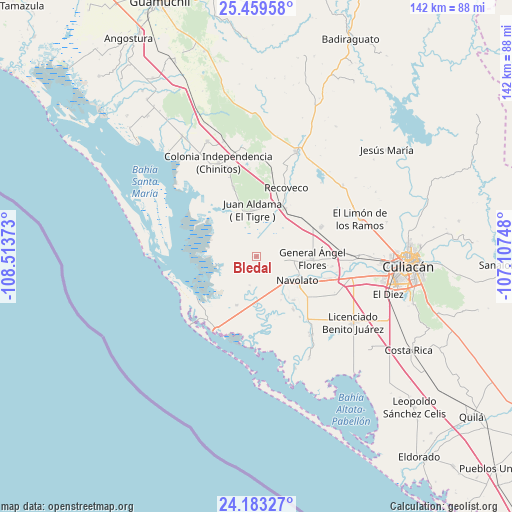
Bledal GPS coordinates[2]
24° 49' 23.052" North, 107° 48' 38.16" West
| Map corner | latitude | longitude |
|---|---|---|
| Upper-left | 25.45958°, | -108.51373° |
| Center: | 24.82307°, | -107.8106° |
| Lower-right: | 24.18327°, | -107.10748° |
| Map W x H: | 141.9×141.9 km | = 88.2×88.2mi |
| max Lat: | 32.7° ⇑8.4% North |
| Bledal: | 24.82307° |
| min Lat: | ⇓91.6% South 14.53588° |
| min Long | Bledal | max Long |
| -117.105° | -107.8106° | -86.73105° |
| W 4.6%⇐ | ⇒95.4% E |
Elevation
Elevation of Bledal is 7 m = 23 ft, and this is 1246.7 m = 4090 ft below average elevation for this country.
| Max E: |
3497 m = 11473 ft | 98.7% |
| Avg. | 1253.7 m = 4113 ft | |
| Bledal | 7 m = 23 ft | |
Min E: |
-1 m = -3 ft | 1.3% |
See also: Mexico elevation on elevation.city.
Geographical zone
Bledal is located in North temperate zone (between Tropic of Cancer and the Arctic Circle). Distance of this Northern Tropic circle is 154.1 km =95.8 mi to South.| Distance of | km | miles | from Bledal |
|---|---|---|---|
| North Pole | 7247 | 4503.1 | to North |
| Arctic Circle | 4641.1 | 2883.8 | to North |
| Tropic Cancer | 154.1 | 95.8 | to South |
| Equator | 2760.1 | 1715 | to South |


Nearby cities:
15 places around Bledal: (largest is in red/bold)
• Bachimeto
11.3 km =7 mi,  143°
143°
• Bachoco
3.3 km =2.1 mi,  166°
166°
• Campo Cinco Hermanos (Emiliano Zapata)
5.2 km =3.2 mi,  251°
251°
• El Vergel
11.9 km =7.4 mi, 174°
• Ezequiel Leyva (Tacuache)
12.2 km =7.6 mi, 172°
• General Ángel Flores (La Palma)
15.5 km =9.6 mi,  91°
91°
• Juan Aldama (El Tigre)
13 km =8.1 mi,  355°
355°
• Juan Escutia
15.2 km =9.4 mi,  30°
30°
• La Bandera
14.5 km =9 mi,  201°
201°
• Las Trancas
13.9 km =8.6 mi,  150°
150°
• Licenciado Alfredo Valdez Montoya
13.5 km =8.4 mi,  185°
185°
• Lo de Reyes
8.1 km =5 mi, 150°
• Navolato
12.6 km =7.8 mi,  120°
120°
• Otameto
12.7 km =7.9 mi, 145°
• Tabolato
11.8 km =7.3 mi,  132°
132°
Sources, notices
• [Note1] Compared only with cities in Mexico existing in our database
• [Src1] Map data: © OpenStreetMap contributors (CC-BY-SA)
• [Src2] Other city data from geonames.org with taken over terms of usage.
• [Src3] Geographical zone / Annual Mean Temperature by Robert A. Rohde @ Wikipedia
