La Limita de Itaje geodata
La Limita de Itaje (Sinaloa) is a populated place; located in Mexico in America/Mazatlan (GMT-7) time zone. With population of 584 people, there are 14684 cities with bigger population in this country. Compared to other cities in Mexico, 91.5% of cities are located further ↓South; 94.8% of cities are located further →East and 84.5% of cities have higher elevation than La Limita de Itaje. Note1


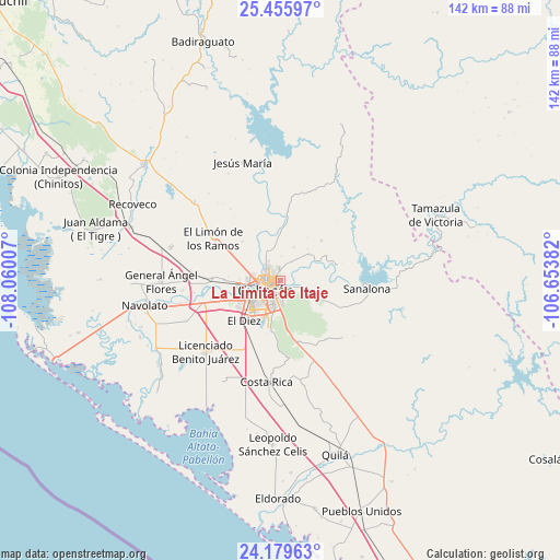
La Limita de Itaje GPS coordinates[2]
24° 49' 9.984" North, 107° 21' 24.984" West
| Map corner | latitude | longitude |
|---|---|---|
| Upper-left | 25.45597°, | -108.06007° |
| Center: | 24.81944°, | -107.35694° |
| Lower-right: | 24.17963°, | -106.65382° |
| Map W x H: | 141.9×141.9 km | = 88.2×88.2mi |
| max Lat: | 32.7° ⇑8.5% North |
| La Limita de Itaje: | 24.81944° |
| min Lat: | ⇓91.5% South 14.53588° |
| min Long | La Limita de It | max Long |
| -117.105° | -107.35694° | -86.73105° |
| W 5.2%⇐ | ⇒94.8% E |
Elevation
Elevation of La Limita de Itaje is 48 m = 157 ft, and this is 1205.7 m = 3956 ft below average elevation for this country.
| Max E: |
3497 m = 11473 ft | 84.5% |
| Avg. | 1253.7 m = 4113 ft | |
| La Limita de Itaje | 48 m = 157 ft | |
Min E: |
-1 m = -3 ft | 15.5% |
See also: Mexico elevation on elevation.city.
Geographical zone
La Limita de Itaje is located in North temperate zone (between Tropic of Cancer and the Arctic Circle). Distance of this Northern Tropic circle is 153.7 km =95.5 mi to South.| Distance of | km | miles | from La Limita de Itaje |
|---|---|---|---|
| North Pole | 7247.4 | 4503.3 | to North |
| Arctic Circle | 4641.5 | 2884.1 | to North |
| Tropic Cancer | 153.7 | 95.5 | to South |
| Equator | 2759.7 | 1714.8 | to South |


Nearby cities:
15 places around La Limita de Itaje: (largest is in red/bold)
• Agua Caliente de los Monzón
13 km =8.1 mi,  347°
347°
• Argentina Dos
13.5 km =8.4 mi,  212°
212°
• Bachigualatito
16.4 km =10.2 mi,  223°
223°
• Bacurimí
9.7 km =6 mi,  265°
265°
• Bellavista
10.6 km =6.6 mi, 266°
• Carbonéras
12.2 km =7.6 mi,  113°
113°
• Culiacancito
17.9 km =11.1 mi, 272°
• Culiacán
4.5 km =2.8 mi, 223°
• Ejido el Quemadito
14.8 km =9.2 mi,  203°
203°
• El Diez
14.3 km =8.9 mi, 222°
• El Pozo
14.5 km =9 mi,  45°
45°
• El Ranchito
8.4 km =5.2 mi,  193°
193°
• El Tepuche
13.8 km =8.6 mi,  3°
3°
• La Palmita y Anexos (La Presita)
13.8 km =8.6 mi,  316°
316°
• Laguna Colorada
16.1 km =10 mi,  162°
162°
Sources, notices
• [Note1] Compared only with cities in Mexico existing in our database
• [Src1] Map data: © OpenStreetMap contributors (CC-BY-SA)
• [Src2] Other city data from geonames.org with taken over terms of usage.
• [Src3] Geographical zone / Annual Mean Temperature by Robert A. Rohde @ Wikipedia
