Las Playitas geodata
Las Playitas (Sonora) is a populated place; located in Mexico in America/Hermosillo (GMT-7) time zone. With population of 794 people, there are 10982 cities with bigger population in this country. Compared to other cities in Mexico, 96.3% of cities are located further ↓South; 97.6% of cities are located further →East and 90.4% of cities have higher elevation than Las Playitas. Note1


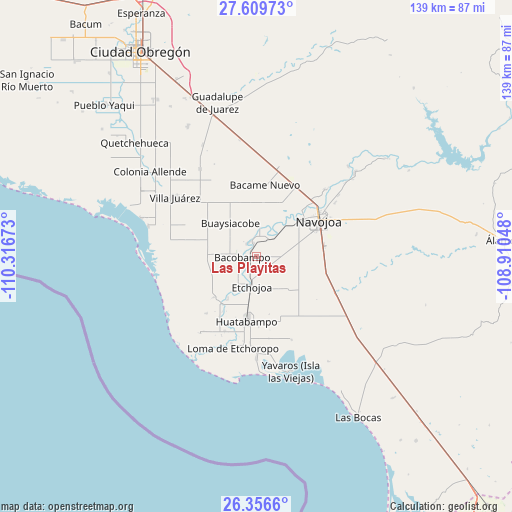
Las Playitas GPS coordinates[2]
26° 59' 5.676" North, 109° 36' 48.96" West
| Map corner | latitude | longitude |
|---|---|---|
| Upper-left | 27.60973°, | -110.31673° |
| Center: | 26.98491°, | -109.6136° |
| Lower-right: | 26.3566°, | -108.91048° |
| Map W x H: | 139.3×139.3 km | = 86.6×86.6mi |
| max Lat: | 32.7° ⇑3.7% North |
| Las Playitas: | 26.98491° |
| min Lat: | ⇓96.3% South 14.53588° |
| min Long | Las Playitas | max Long |
| -117.105° | -109.6136° | -86.73105° |
| W 2.4%⇐ | ⇒97.6% E |
Elevation
Elevation of Las Playitas is 23 m = 75 ft, and this is 1230.7 m = 4038 ft below average elevation for this country.
| Max E: |
3497 m = 11473 ft | 90.4% |
| Avg. | 1253.7 m = 4113 ft | |
| Las Playitas | 23 m = 75 ft | |
Min E: |
-1 m = -3 ft | 9.6% |
See also: Mexico elevation on elevation.city.
Geographical zone
Las Playitas is located in North temperate zone (between Tropic of Cancer and the Arctic Circle). Distance of this Northern Tropic circle is 394.5 km =245.1 mi to South.| Distance of | km | miles | from Las Playitas |
|---|---|---|---|
| North Pole | 7006.6 | 4353.7 | to North |
| Arctic Circle | 4400.7 | 2734.5 | to North |
| Tropic Cancer | 394.5 | 245.1 | to South |
| Equator | 3000.4 | 1864.4 | to South |


Nearby cities:
15 places around Las Playitas: (largest is in red/bold)
• Aquichopo
11.5 km =7.1 mi,  27°
27°
• Bacobampo
4 km =2.5 mi,  265°
265°
• Basconcobe
6.4 km =4 mi,  238°
238°
• Chinotahueca
9.3 km =5.8 mi,  61°
61°
• Chucarit
5.9 km =3.7 mi, 29°
• El Rodeo
4.4 km =2.7 mi,  319°
319°
• El Sahuaral
8.4 km =5.2 mi,  218°
218°
• Etchojoa
8.3 km =5.2 mi,  188°
188°
• Guayparín
3.9 km =2.4 mi, 238°
• Jitonhueca
8.6 km =5.3 mi,  5°
5°
• Mochidaco
7 km =4.3 mi, 220°
• Navolato
7 km =4.3 mi,  39°
39°
• San Pedro Río Mayo
4.4 km =2.7 mi,  335°
335°
• San Pedro Viejo
3.8 km =2.4 mi,  346°
346°
• Villa Tres Cruces
10.3 km =6.4 mi,  211°
211°
Sources, notices
• [Note1] Compared only with cities in Mexico existing in our database
• [Src1] Map data: © OpenStreetMap contributors (CC-BY-SA)
• [Src2] Other city data from geonames.org with taken over terms of usage.
• [Src3] Geographical zone / Annual Mean Temperature by Robert A. Rohde @ Wikipedia
