Coahuayutla de Guerrero geodata
Coahuayutla de Guerrero (Guerrero) is a seat of a second-order administrative division; located in Mexico in America/Mexico_City (GMT-6) time zone. With population of 1,473 people, there are 5868 cities with bigger population in this country. Compared to other cities in Mexico, 74.7% of cities are located further ↑North; 79.3% of cities are located further →East and 72.5% of cities have higher elevation than Coahuayutla de Guerrero. Note1
Current local time in Coahuayutla de Guerrero:
08:35 AM, WednesdayDifference from your time zone: hours


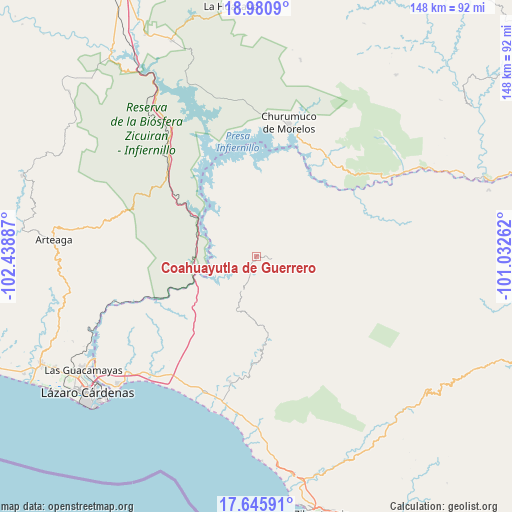
Coahuayutla de Guerrero GPS coordinates[2]
18° 18' 52.884" North, 101° 44' 8.664" West
| Map corner | latitude | longitude |
|---|---|---|
| Upper-left | 18.9809°, | -102.43887° |
| Center: | 18.31469°, | -101.73574° |
| Lower-right: | 17.64591°, | -101.03262° |
| Map W x H: | 148.4×148.4 km | = 92.2×92.2mi |
| max Lat: | 32.7° ⇑74.7% North |
| Coahuayutla de Guerrero: | 18.31469° |
| min Lat: | ⇓25.3% South 14.53588° |
| min Long | Coahuayutla de | max Long |
| -117.105° | -101.73574° | -86.73105° |
| W 20.7%⇐ | ⇒79.3% E |
Elevation
Elevation of Coahuayutla de Guerrero is 313 m = 1027 ft, and this is 940.7 m = 3086 ft below average elevation for this country.
| Max E: |
3497 m = 11473 ft | 72.5% |
| Avg. | 1253.7 m = 4113 ft | |
| Coahuayutla de Guerrero | 313 m = 1027 ft | |
Min E: |
-1 m = -3 ft | 27.5% |
See also: Mexico elevation on elevation.city.
Geographical zone
Coahuayutla de Guerrero is located in North Torrid zone (between Equator and Tropic of Cancer). Distance of this Northern Tropic circle is 569.5 km =353.9 mi to North.| Distance of | km | miles | from Coahuayutla de Guerrero |
|---|---|---|---|
| North Pole | 7970.7 | 4952.8 | to North |
| Arctic Circle | 5364.8 | 3333.5 | to North |
| Tropic Cancer | 569.5 | 353.9 | to North |
| Equator | 2036.4 | 1265.4 | to South |


Nearby cities:
15 places around Coahuayutla de Guerrero: (largest is in red/bold)
• Aratichanguío
43.4 km =27 mi,  65°
65°
• Churumuco de Morelos
39.9 km =24.8 mi,  13°
13°
• El Timbiriche
45.5 km =28.3 mi,  31°
31°
• Feliciano
41.6 km =25.8 mi,  217°
217°
• Guayameo
50.1 km =31.1 mi,  91°
91°
• Infiernillo (Morelos de Infiernillo)
17.8 km =11.1 mi,  258°
258°
• Joluta
42 km =26.1 mi,  208°
208°
• La Unión
37.3 km =23.2 mi,  191°
191°
• Las Cañas
37.7 km =23.4 mi,  317°
317°
• Los Ciriancitos
50.1 km =31.1 mi,  325°
325°
• Los Llanos de Temalhuacán (Los Llanos)
49.9 km =31 mi,  179°
179°
• Palma de Huaro
45.7 km =28.4 mi,  358°
358°
• Rincón de Cucharatepec
33 km =20.5 mi, 205°
• San Jerónimo
49.5 km =30.8 mi,  60°
60°
• Surcua
49.8 km =30.9 mi,  226°
226°
Sources, notices
• [Note1] Compared only with cities in Mexico existing in our database
• [Src1] Map data: © OpenStreetMap contributors (CC-BY-SA)
• [Src2] Other city data from geonames.org with taken over terms of usage.
• [Src3] Geographical zone / Annual Mean Temperature by Robert A. Rohde @ Wikipedia
