Palma de Huaro geodata
Palma de Huaro (Michoacán) is a populated place; located in Mexico in America/Mexico_City (GMT-6) time zone. With population of 622 people, there are 13890 cities with bigger population in this country. Compared to other cities in Mexico, 69.9% of cities are located further ↑North; 79.4% of cities are located further →East and 73.1% of cities have higher elevation than Palma de Huaro. Note1


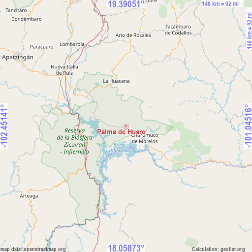
Palma de Huaro GPS coordinates[2]
18° 43' 33.348" North, 101° 44' 53.808" West
| Map corner | latitude | longitude |
|---|---|---|
| Upper-left | 19.39051°, | -102.45141° |
| Center: | 18.72593°, | -101.74828° |
| Lower-right: | 18.05873°, | -101.04516° |
| Map W x H: | 148.1×148.1 km | = 92×92mi |
| max Lat: | 32.7° ⇑69.9% North |
| Palma de Huaro: | 18.72593° |
| min Lat: | ⇓30.1% South 14.53588° |
| min Long | Palma de Huaro | max Long |
| -117.105° | -101.74828° | -86.73105° |
| W 20.6%⇐ | ⇒79.4% E |
Elevation
Elevation of Palma de Huaro is 283 m = 928 ft, and this is 970.7 m = 3185 ft below average elevation for this country.
| Max E: |
3497 m = 11473 ft | 73.1% |
| Avg. | 1253.7 m = 4113 ft | |
| Palma de Huaro | 283 m = 928 ft | |
Min E: |
-1 m = -3 ft | 26.9% |
See also: Mexico elevation on elevation.city.
Geographical zone
Palma de Huaro is located in North Torrid zone (between Equator and Tropic of Cancer). Distance of this Northern Tropic circle is 523.8 km =325.5 mi to North.| Distance of | km | miles | from Palma de Huaro |
|---|---|---|---|
| North Pole | 7924.9 | 4924.3 | to North |
| Arctic Circle | 5319 | 3305.1 | to North |
| Tropic Cancer | 523.8 | 325.5 | to North |
| Equator | 2082.1 | 1293.8 | to South |


Nearby cities:
15 places around Palma de Huaro: (largest is in red/bold)
• Bellas Fuentes (Nuevo Centro)
27.2 km =16.9 mi,  274°
274°
• Churumuco de Morelos
12.7 km =7.9 mi,  123°
123°
• El Chauz
35.8 km =22.2 mi,  301°
301°
• El Timbiriche
26.2 km =16.3 mi,  105°
105°
• Ichamio
26.4 km =16.4 mi,  342°
342°
• La Huacana
27.1 km =16.8 mi,  346°
346°
• Las Cañas
29.9 km =18.6 mi,  233°
233°
• Las Puentes
36.4 km =22.6 mi,  15°
15°
• Los Ciriancitos
27.2 km =16.9 mi,  260°
260°
• Mata de Plátano
26.1 km =16.2 mi,  8°
8°
• Nuevo Capirio
42 km =26.1 mi,  291°
291°
• Poturo
18 km =11.2 mi,  51°
51°
• Tavera
42.3 km =26.3 mi,  28°
28°
• Urapa
42.7 km =26.5 mi, 10°
• Zicuirán
28.7 km =17.8 mi,  306°
306°
Sources, notices
• [Note1] Compared only with cities in Mexico existing in our database
• [Src1] Map data: © OpenStreetMap contributors (CC-BY-SA)
• [Src2] Other city data from geonames.org with taken over terms of usage.
• [Src3] Geographical zone / Annual Mean Temperature by Robert A. Rohde @ Wikipedia
