Cotorina geodata
Cotorina (Aguascalientes) is a populated place; located in Mexico in America/Mexico_City (GMT-6) time zone. With population of 1,298 people, there are 6677 cities with bigger population in this country. Compared to other cities in Mexico, 82.7% of cities are located further ↓South; 82.5% of cities are located further →East and 68.3% of cities have lower elevation than Cotorina. Note1


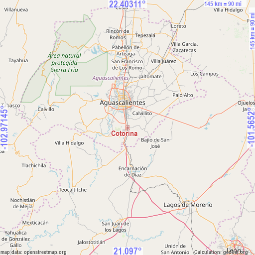
Cotorina GPS coordinates[2]
21° 45' 5.544" North, 102° 16' 5.952" West
| Map corner | latitude | longitude |
|---|---|---|
| Upper-left | 22.40311°, | -102.97145° |
| Center: | 21.75154°, | -102.26832° |
| Lower-right: | 21.097°, | -101.5652° |
| Map W x H: | 145.2×145.2 km | = 90.2×90.2mi |
| max Lat: | 32.7° ⇑17.3% North |
| Cotorina: | 21.75154° |
| min Lat: | ⇓82.7% South 14.53588° |
| min Long | Cotorina | max Long |
| -117.105° | -102.26832° | -86.73105° |
| W 17.5%⇐ | ⇒82.5% E |
Elevation
Elevation of Cotorina is 1895 m = 6217 ft, and this is 641.3 m = 2104 ft above average elevation for this country.
| Max E: |
3497 m = 11473 ft | 31.7% |
| Cotorina | 1895 m 6217 ft | |
| Avg. | 1253.7 m = 4113 ft | |
Min E: |
-1 m = -3 ft | 68.3% |
See also: Mexico elevation on elevation.city.
Geographical zone
Cotorina is located in North Torrid zone (between Equator and Tropic of Cancer). Distance of this Northern Tropic circle is 187.4 km =116.4 mi to North.| Distance of | km | miles | from Cotorina |
|---|---|---|---|
| North Pole | 7588.5 | 4715.3 | to North |
| Arctic Circle | 4982.6 | 3096 | to North |
| Tropic Cancer | 187.4 | 116.4 | to North |
| Equator | 2418.5 | 1502.8 | to South |


Nearby cities:
15 places around Cotorina: (largest is in red/bold)
• Aguascalientes
14.6 km =9.1 mi,  354°
354°
• Arellano
5.5 km =3.4 mi, 354°
• Buenavista de Peñuelas
4.7 km =2.9 mi,  216°
216°
• El Refugio de Peñuelas
4.5 km =2.8 mi,  209°
209°
• El Retoño
14.4 km =8.9 mi,  47°
47°
• El Tanque de los Jiménez
11.9 km =7.4 mi,  246°
246°
• La Loma de los Negritos
15.7 km =9.8 mi,  327°
327°
• Montoro
3.5 km =2.2 mi,  278°
278°
• Norias del Paso Hondo
13.8 km =8.6 mi,  27°
27°
• Peñuelas (El Cienegal)
3.3 km =2.1 mi,  193°
193°
• Residencial San Nicolás [Baños la Cantera]
14.3 km =8.9 mi,  320°
320°
• San Antonio de Peñuelas
9.2 km =5.7 mi,  201°
201°
• San Sebastián [Fraccionamiento]
7.8 km =4.8 mi,  357°
357°
• Villa Licenciado Jesús Terán (Calvillito)
11.7 km =7.3 mi, 45°
• Villas del Mediterráneo
12 km =7.5 mi, 328°
Sources, notices
• [Note1] Compared only with cities in Mexico existing in our database
• [Src1] Map data: © OpenStreetMap contributors (CC-BY-SA)
• [Src2] Other city data from geonames.org with taken over terms of usage.
• [Src3] Geographical zone / Annual Mean Temperature by Robert A. Rohde @ Wikipedia
