Villa Licenciado Jesús Terán (Calvillito) geodata
Villa Licenciado Jesús Terán (Calvillito) (Aguascalientes) is a populated place; located in Mexico in America/Mexico_City (GMT-6) time zone. With population of 4,481 people, there are 2056 cities with bigger population in this country. Compared to other cities in Mexico, 83.1% of cities are located further ↓South; 81.9% of cities are located further →East and 71.2% of cities have lower elevation than Villa Licenciado Jesús Terán (Calvillito). Note1
Current local time in Villa Licenciado Jesús Terán (Calvillito):
08:45 AM, MondayDifference from your time zone: hours


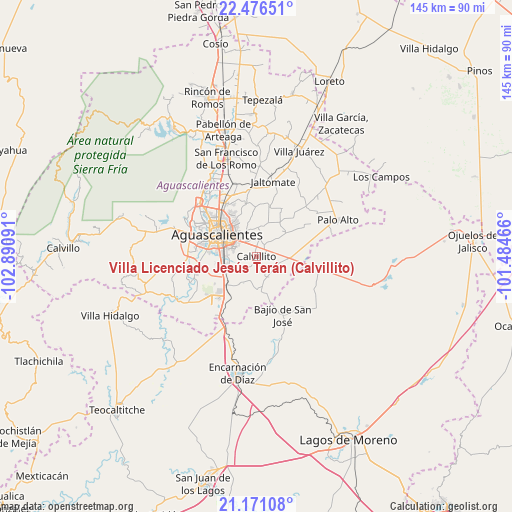
Villa Licenciado Jesús Terán (Calvillito) GPS coordinates[2]
21° 49' 31.008" North, 102° 11' 16.008" West
| Map corner | latitude | longitude |
|---|---|---|
| Upper-left | 22.47651°, | -102.89091° |
| Center: | 21.82528°, | -102.18778° |
| Lower-right: | 21.17108°, | -101.48466° |
| Map W x H: | 145.2×145.2 km | = 90.2×90.2mi |
| max Lat: | 32.7° ⇑16.9% North |
| Villa Licenciado Jesús Terán (Calvillito): | 21.82528° |
| min Lat: | ⇓83.1% South 14.53588° |
| min Long | Villa Licenciad | max Long |
| -117.105° | -102.18778° | -86.73105° |
| W 18.1%⇐ | ⇒81.9% E |
Elevation
Elevation of Villa Licenciado Jesús Terán (Calvillito) is 1950 m = 6398 ft, and this is 696.3 m = 2284 ft above average elevation for this country.
| Max E: |
3497 m = 11473 ft | 28.8% |
| Villa Licenciado Jesús Terán (Calvillito) | 1950 m 6398 ft | |
| Avg. | 1253.7 m = 4113 ft | |
Min E: |
-1 m = -3 ft | 71.2% |
See also: Mexico elevation on elevation.city.
Geographical zone
Villa Licenciado Jesús Terán (Calvillito) is located in North Torrid zone (between Equator and Tropic of Cancer). Distance of this Northern Tropic circle is 179.2 km =111.3 mi to North.| Distance of | km | miles | from Villa Licenciado Jesús Terán (Calvillito) |
|---|---|---|---|
| North Pole | 7580.3 | 4710.2 | to North |
| Arctic Circle | 4974.4 | 3090.9 | to North |
| Tropic Cancer | 179.2 | 111.3 | to North |
| Equator | 2426.7 | 1507.9 | to South |


Nearby cities:
15 places around Villa Licenciado Jesús Terán (Calvillito): (largest is in red/bold)
• Aguascalientes
11.7 km =7.3 mi,  302°
302°
• Arellano
9.3 km =5.8 mi,  253°
253°
• Conejal
10.5 km =6.5 mi,  348°
348°
• Cotorina
11.7 km =7.3 mi,  225°
225°
• Cumbres III
11.9 km =7.4 mi,  334°
334°
• El Refugio de Peñuelas
16 km =9.9 mi,  220°
220°
• El Retoño
2.7 km =1.7 mi,  54°
54°
• Las Güeras
14.2 km =8.8 mi,  145°
145°
• Las Norias de Ojocaliente
7.8 km =4.8 mi,  336°
336°
• Montebello Della Stanza [Fraccionamiento]
15.1 km =9.4 mi,  324°
324°
• Montoro
14.1 km =8.8 mi,  236°
236°
• Norias del Paso Hondo
4.5 km =2.8 mi, 334°
• Peñuelas (El Cienegal)
14.6 km =9.1 mi, 218°
• San Sebastián [Fraccionamiento]
8.6 km =5.3 mi,  267°
267°
• Villas del Mediterráneo
14.8 km =9.2 mi,  277°
277°
Sources, notices
• [Note1] Compared only with cities in Mexico existing in our database
• [Src1] Map data: © OpenStreetMap contributors (CC-BY-SA)
• [Src2] Other city data from geonames.org with taken over terms of usage.
• [Src3] Geographical zone / Annual Mean Temperature by Robert A. Rohde @ Wikipedia
