El Retoño geodata
El Retoño (Aguascalientes) is a populated place; located in Mexico in America/Mexico_City (GMT-6) time zone. With population of 591 people, there are 14530 cities with bigger population in this country. Compared to other cities in Mexico, 83.2% of cities are located further ↓South; 81.8% of cities are located further →East and 73.9% of cities have lower elevation than El Retoño. Note1


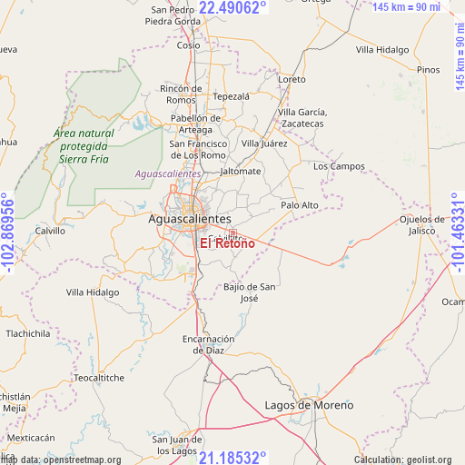
El Retoño GPS coordinates[2]
21° 50' 22.056" North, 102° 9' 59.148" West
| Map corner | latitude | longitude |
|---|---|---|
| Upper-left | 22.49062°, | -102.86956° |
| Center: | 21.83946°, | -102.16643° |
| Lower-right: | 21.18532°, | -101.46331° |
| Map W x H: | 145.1×145.1 km | = 90.2×90.2mi |
| max Lat: | 32.7° ⇑16.8% North |
| El Retoño: | 21.83946° |
| min Lat: | ⇓83.2% South 14.53588° |
| min Long | El Retoño | max Long |
| -117.105° | -102.16643° | -86.73105° |
| W 18.2%⇐ | ⇒81.8% E |
Elevation
Elevation of El Retoño is 2008 m = 6588 ft, and this is 754.3 m = 2475 ft above average elevation for this country.
| Max E: |
3497 m = 11473 ft | 26.1% |
| El Retoño | 2008 m 6588 ft | |
| Avg. | 1253.7 m = 4113 ft | |
Min E: |
-1 m = -3 ft | 73.9% |
See also: Mexico elevation on elevation.city.
Geographical zone
El Retoño is located in North Torrid zone (between Equator and Tropic of Cancer). Distance of this Northern Tropic circle is 177.6 km =110.4 mi to North.| Distance of | km | miles | from El Retoño |
|---|---|---|---|
| North Pole | 7578.7 | 4709.2 | to North |
| Arctic Circle | 4972.9 | 3090 | to North |
| Tropic Cancer | 177.6 | 110.4 | to North |
| Equator | 2428.3 | 1508.9 | to South |


Nearby cities:
15 places around El Retoño: (largest is in red/bold)
• Aguascalientes
12.9 km =8 mi,  291°
291°
• Arellano
11.9 km =7.4 mi,  248°
248°
• Conejal
9.7 km =6 mi,  334°
334°
• Cotorina
14.4 km =8.9 mi,  227°
227°
• Cumbres III
11.8 km =7.3 mi,  321°
321°
• Las Güeras
14.5 km =9 mi,  156°
156°
• Las Norias de Ojocaliente
7.7 km =4.8 mi, 316°
• Matamoros los Hoyos
14.8 km =9.2 mi,  91°
91°
• Montebello Della Stanza [Fraccionamiento]
15.4 km =9.6 mi,  314°
314°
• Montoro
16.8 km =10.4 mi,  236°
236°
• Norias del Paso Hondo
4.8 km =3 mi,  300°
300°
• Puertecito de la Virgen
17.1 km =10.6 mi, 321°
• San Sebastián [Fraccionamiento]
11 km =6.8 mi,  259°
259°
• Villa Licenciado Jesús Terán (Calvillito)
2.7 km =1.7 mi, 234°
• Villas del Mediterráneo
16.8 km =10.4 mi,  271°
271°
Sources, notices
• [Note1] Compared only with cities in Mexico existing in our database
• [Src1] Map data: © OpenStreetMap contributors (CC-BY-SA)
• [Src2] Other city data from geonames.org with taken over terms of usage.
• [Src3] Geographical zone / Annual Mean Temperature by Robert A. Rohde @ Wikipedia
