Clavellinas geodata
Clavellinas (Aguascalientes) is a populated place; located in Mexico in America/Mexico_City (GMT-6) time zone. With population of 614 people, there are 14035 cities with bigger population in this country. Compared to other cities in Mexico, 84.9% of cities are located further ↓South; 81.7% of cities are located further →East and 78.2% of cities have lower elevation than Clavellinas. Note1


Clavellinas GPS coordinates[2]
22° 8' 25.08" North, 102° 8' 15" West
| Map corner | latitude | longitude |
|---|---|---|
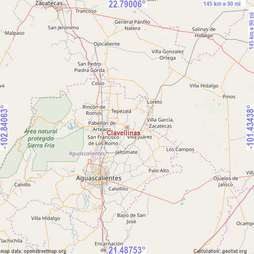
| Upper-left | 22.79006°, | -102.84063° |
| Center: | 22.1403°, | -102.1375° |
| Lower-right: | 21.48753°, | -101.43438° |
| Map W x H: | 144.8×144.8 km | = 90×90mi |
| max Lat: | 32.7° ⇑15.1% North |
| Clavellinas: | 22.1403° |
| min Lat: | ⇓84.9% South 14.53588° |
| min Long | Clavellinas | max Long |
| -117.105° | -102.1375° | -86.73105° |
| W 18.3%⇐ | ⇒81.7% E |
Elevation
Elevation of Clavellinas is 2093 m = 6867 ft, and this is 839.3 m = 2754 ft above average elevation for this country.
| Max E: |
3497 m = 11473 ft | 21.8% |
| Clavellinas | 2093 m 6867 ft | |
| Avg. | 1253.7 m = 4113 ft | |
Min E: |
-1 m = -3 ft | 78.2% |
See also: Mexico elevation on elevation.city.
Geographical zone
Clavellinas is located in North Torrid zone (between Equator and Tropic of Cancer). Distance of this Northern Tropic circle is 144.1 km =89.5 mi to North.| Distance of | km | miles | from Clavellinas |
|---|---|---|---|
| North Pole | 7545.3 | 4688.4 | to North |
| Arctic Circle | 4939.4 | 3069.2 | to North |
| Tropic Cancer | 144.1 | 89.5 | to North |
| Equator | 2461.8 | 1529.7 | to South |


Nearby cities:
15 places around Clavellinas: (largest is in red/bold)
• Asientos
12 km =7.5 mi,  24°
24°
• El Polvo
3.1 km =1.9 mi,  103°
103°
• El Refugio
9.9 km =6.2 mi,  290°
290°
• El Tepozán
3.4 km =2.1 mi,  351°
351°
• El Tule
7.8 km =4.8 mi,  142°
142°
• La Dichosa
11.3 km =7 mi,  166°
166°
• Lázaro Cárdenas
11.9 km =7.4 mi,  73°
73°
• Molinos
5.1 km =3.2 mi,  60°
60°
• Ojo Zarco
11.3 km =7 mi,  251°
251°
• Pino Suárez
4.3 km =2.7 mi,  51°
51°
• San José del Río
8 km =5 mi, 103°
• Santa María Gallardo
10.4 km =6.5 mi, 167°
• Tepezalá
9.9 km =6.2 mi,  340°
340°
• Villa Juárez
8.7 km =5.4 mi,  125°
125°
• Viudas de Poniente
6.8 km =4.2 mi, 127°
Sources, notices
• [Note1] Compared only with cities in Mexico existing in our database
• [Src1] Map data: © OpenStreetMap contributors (CC-BY-SA)
• [Src2] Other city data from geonames.org with taken over terms of usage.
• [Src3] Geographical zone / Annual Mean Temperature by Robert A. Rohde @ Wikipedia
