Providencia geodata
Providencia (Guanajuato) is a populated place; located in Mexico in America/Mexico_City (GMT-6) time zone. With population of 1,173 people, there are 7403 cities with bigger population in this country. Compared to other cities in Mexico, 64.6% of cities are located further ↓South; 73.6% of cities are located further →East and 60.7% of cities have lower elevation than Providencia. Note1


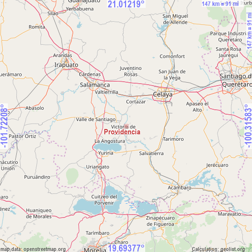
Providencia GPS coordinates[2]
20° 21' 15.804" North, 101° 1' 8.22" West
| Map corner | latitude | longitude |
|---|---|---|
| Upper-left | 21.01219°, | -101.72208° |
| Center: | 20.35439°, | -101.01895° |
| Lower-right: | 19.69377°, | -100.31583° |
| Map W x H: | 146.6×146.6 km | = 91.1×91.1mi |
| max Lat: | 32.7° ⇑35.4% North |
| Providencia: | 20.35439° |
| min Lat: | ⇓64.6% South 14.53588° |
| min Long | Providencia | max Long |
| -117.105° | -101.01895° | -86.73105° |
| W 26.4%⇐ | ⇒73.6% E |
Elevation
Elevation of Providencia is 1737 m = 5699 ft, and this is 483.3 m = 1586 ft above average elevation for this country.
| Max E: |
3497 m = 11473 ft | 39.3% |
| Providencia | 1737 m 5699 ft | |
| Avg. | 1253.7 m = 4113 ft | |
Min E: |
-1 m = -3 ft | 60.7% |
See also: Mexico elevation on elevation.city.
Geographical zone
Providencia is located in North Torrid zone (between Equator and Tropic of Cancer). Distance of this Northern Tropic circle is 342.7 km =212.9 mi to North.| Distance of | km | miles | from Providencia |
|---|---|---|---|
| North Pole | 7743.9 | 4811.8 | to North |
| Arctic Circle | 5138 | 3192.6 | to North |
| Tropic Cancer | 342.7 | 212.9 | to North |
| Equator | 2263.2 | 1406.3 | to South |


Nearby cities:
15 places around Providencia: (largest is in red/bold)
• Cañada de Caracheo
8 km =5 mi,  72°
72°
• El Diezmo
8.4 km =5.2 mi,  2°
2°
• El Sabino
8.3 km =5.2 mi,  167°
167°
• Hacienda de la Bolsa
9.2 km =5.7 mi,  284°
284°
• Jaral del Progreso
5 km =3.1 mi,  293°
293°
• La Mocha
6.1 km =3.8 mi,  20°
20°
• Loma de Zempoala
9.4 km =5.8 mi,  222°
222°
• Los Llanitos (El Ranchito)
8.2 km =5.1 mi, 288°
• San Isidro Culiacán
2.6 km =1.6 mi,  60°
60°
• San José de Ojo Zarco
3.4 km =2.1 mi,  186°
186°
• San José del Cerrito de Camargo
7.6 km =4.7 mi,  341°
341°
• San Nicolás de Manantiales
7.3 km =4.5 mi,  50°
50°
• Santiago Capitiro
5.6 km =3.5 mi,  178°
178°
• Victoria de Cortazar
2.6 km =1.6 mi,  211°
211°
• Zempoala
7.4 km =4.6 mi,  236°
236°
Sources, notices
• [Note1] Compared only with cities in Mexico existing in our database
• [Src1] Map data: © OpenStreetMap contributors (CC-BY-SA)
• [Src2] Other city data from geonames.org with taken over terms of usage.
• [Src3] Geographical zone / Annual Mean Temperature by Robert A. Rohde @ Wikipedia
