Zempoala geodata
Zempoala (Guanajuato) is a populated place; located in Mexico in America/Mexico_City (GMT-6) time zone. With population of 746 people, there are 11739 cities with bigger population in this country. Compared to other cities in Mexico, 63.9% of cities are located further ↓South; 74.1% of cities are located further →East and 60.5% of cities have lower elevation than Zempoala. Note1


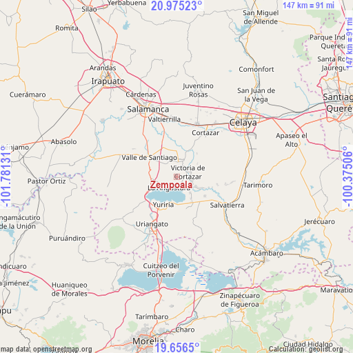
Zempoala GPS coordinates[2]
20° 19' 2.172" North, 101° 4' 41.448" West
| Map corner | latitude | longitude |
|---|---|---|
| Upper-left | 20.97523°, | -101.78131° |
| Center: | 20.31727°, | -101.07818° |
| Lower-right: | 19.6565°, | -100.37506° |
| Map W x H: | 146.6×146.6 km | = 91.1×91.1mi |
| max Lat: | 32.7° ⇑36.1% North |
| Zempoala: | 20.31727° |
| min Lat: | ⇓63.9% South 14.53588° |
| min Long | Zempoala | max Long |
| -117.105° | -101.07818° | -86.73105° |
| W 25.9%⇐ | ⇒74.1% E |
Elevation
Elevation of Zempoala is 1734 m = 5689 ft, and this is 480.3 m = 1576 ft above average elevation for this country.
| Max E: |
3497 m = 11473 ft | 39.5% |
| Zempoala | 1734 m 5689 ft | |
| Avg. | 1253.7 m = 4113 ft | |
Min E: |
-1 m = -3 ft | 60.5% |
See also: Mexico elevation on elevation.city.
Geographical zone
Zempoala is located in North Torrid zone (between Equator and Tropic of Cancer). Distance of this Northern Tropic circle is 346.9 km =215.6 mi to North.| Distance of | km | miles | from Zempoala |
|---|---|---|---|
| North Pole | 7748 | 4814.4 | to North |
| Arctic Circle | 5142.1 | 3195.2 | to North |
| Tropic Cancer | 346.9 | 215.6 | to North |
| Equator | 2259.1 | 1403.7 | to South |


Nearby cities:
15 places around Zempoala: (largest is in red/bold)
• Bella Vista de Santa María
6.7 km =4.2 mi,  318°
318°
• Cahuageo
7.2 km =4.5 mi,  229°
229°
• El Perico
7.4 km =4.6 mi,  305°
305°
• Gervasio Mendoza
7.6 km =4.7 mi,  245°
245°
• Hacienda de la Bolsa
7 km =4.3 mi,  337°
337°
• Jaral del Progreso
6.3 km =3.9 mi,  14°
14°
• La Angostura
5.5 km =3.4 mi,  216°
216°
• Loma de Zempoala
2.8 km =1.7 mi,  184°
184°
• Los Llanitos (El Ranchito)
6.9 km =4.3 mi,  346°
346°
• Pozo de Aróstegui (Las Correas)
7.9 km =4.9 mi,  302°
302°
• Providencia
7.4 km =4.6 mi,  56°
56°
• San José de Ojo Zarco
5.8 km =3.6 mi,  82°
82°
• Santa Ana
7.2 km =4.5 mi,  330°
330°
• Santiago Capitiro
6.5 km =4 mi,  102°
102°
• Victoria de Cortazar
5.2 km =3.2 mi,  68°
68°
Sources, notices
• [Note1] Compared only with cities in Mexico existing in our database
• [Src1] Map data: © OpenStreetMap contributors (CC-BY-SA)
• [Src2] Other city data from geonames.org with taken over terms of usage.
• [Src3] Geographical zone / Annual Mean Temperature by Robert A. Rohde @ Wikipedia
