Gervasio Mendoza geodata
Gervasio Mendoza (Guanajuato) is a populated place; located in Mexico in America/Mexico_City (GMT-6) time zone. With population of 785 people, there are 11128 cities with bigger population in this country. Compared to other cities in Mexico, 63.3% of cities are located further ↓South; 74.6% of cities are located further →East and 61.4% of cities have lower elevation than Gervasio Mendoza. Note1


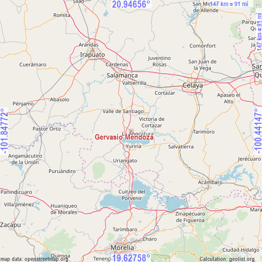
Gervasio Mendoza GPS coordinates[2]
20° 17' 18.492" North, 101° 8' 40.524" West
| Map corner | latitude | longitude |
|---|---|---|
| Upper-left | 20.94656°, | -101.84772° |
| Center: | 20.28847°, | -101.14459° |
| Lower-right: | 19.62758°, | -100.44147° |
| Map W x H: | 146.7×146.7 km | = 91.2×91.2mi |
| max Lat: | 32.7° ⇑36.7% North |
| Gervasio Mendoza: | 20.28847° |
| min Lat: | ⇓63.3% South 14.53588° |
| min Long | Gervasio Mendoz | max Long |
| -117.105° | -101.14459° | -86.73105° |
| W 25.4%⇐ | ⇒74.6% E |
Elevation
Elevation of Gervasio Mendoza is 1749 m = 5738 ft, and this is 495.3 m = 1625 ft above average elevation for this country.
| Max E: |
3497 m = 11473 ft | 38.6% |
| Gervasio Mendoza | 1749 m 5738 ft | |
| Avg. | 1253.7 m = 4113 ft | |
Min E: |
-1 m = -3 ft | 61.4% |
See also: Mexico elevation on elevation.city.
Geographical zone
Gervasio Mendoza is located in North Torrid zone (between Equator and Tropic of Cancer). Distance of this Northern Tropic circle is 350.1 km =217.5 mi to North.| Distance of | km | miles | from Gervasio Mendoza |
|---|---|---|---|
| North Pole | 7751.2 | 4816.4 | to North |
| Arctic Circle | 5145.3 | 3197.1 | to North |
| Tropic Cancer | 350.1 | 217.5 | to North |
| Equator | 2255.9 | 1401.8 | to South |


Nearby cities:
15 places around Gervasio Mendoza: (largest is in red/bold)
• Bella Vista de Santa María
8.6 km =5.3 mi,  16°
16°
• Cahuageo
2.1 km =1.3 mi,  135°
135°
• Crucitas
10 km =6.2 mi,  320°
320°
• El Perico
7.5 km =4.7 mi,  6°
6°
• La Angostura
3.8 km =2.4 mi,  108°
108°
• Loma de Zempoala
6.7 km =4.2 mi,  86°
86°
• Magdalena de Araceo
4.2 km =2.6 mi,  303°
303°
• Ochomitas
9.6 km =6 mi,  221°
221°
• Pozo de Aróstegui (Las Correas)
7.4 km =4.6 mi,  2°
2°
• Ranchos Unidos
8.9 km =5.5 mi,  311°
311°
• San Jerónimo de Araceo
5.6 km =3.5 mi, 316°
• San Miguel el Alto (San Miguelito)
9.7 km =6 mi,  202°
202°
• Santa Ana
10 km =6.2 mi, 19°
• Yuriria
8.7 km =5.4 mi,  171°
171°
• Zempoala
7.6 km =4.7 mi,  65°
65°
Sources, notices
• [Note1] Compared only with cities in Mexico existing in our database
• [Src1] Map data: © OpenStreetMap contributors (CC-BY-SA)
• [Src2] Other city data from geonames.org with taken over terms of usage.
• [Src3] Geographical zone / Annual Mean Temperature by Robert A. Rohde @ Wikipedia
