San Vicente de Flores geodata
San Vicente de Flores (Guanajuato) is a populated place; located in Mexico in America/Mexico_City (GMT-6) time zone. With population of 1,001 people, there are 8710 cities with bigger population in this country. Compared to other cities in Mexico, 70.4% of cities are located further ↓South; 75.3% of cities are located further →East and 59.3% of cities have lower elevation than San Vicente de Flores. Note1


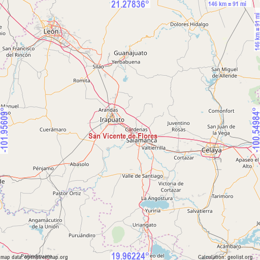
San Vicente de Flores GPS coordinates[2]
20° 37' 18.192" North, 101° 15' 10.656" West
| Map corner | latitude | longitude |
|---|---|---|
| Upper-left | 21.27836°, | -101.95609° |
| Center: | 20.62172°, | -101.25296° |
| Lower-right: | 19.96224°, | -100.54984° |
| Map W x H: | 146.3×146.3 km | = 90.9×90.9mi |
| max Lat: | 32.7° ⇑29.6% North |
| San Vicente de Flores: | 20.62172° |
| min Lat: | ⇓70.4% South 14.53588° |
| min Long | San Vicente de | max Long |
| -117.105° | -101.25296° | -86.73105° |
| W 24.7%⇐ | ⇒75.3% E |
Elevation
Elevation of San Vicente de Flores is 1715 m = 5627 ft, and this is 461.3 m = 1513 ft above average elevation for this country.
| Max E: |
3497 m = 11473 ft | 40.7% |
| San Vicente de Flores | 1715 m 5627 ft | |
| Avg. | 1253.7 m = 4113 ft | |
Min E: |
-1 m = -3 ft | 59.3% |
See also: Mexico elevation on elevation.city.
Geographical zone
San Vicente de Flores is located in North Torrid zone (between Equator and Tropic of Cancer). Distance of this Northern Tropic circle is 313 km =194.5 mi to North.| Distance of | km | miles | from San Vicente de Flores |
|---|---|---|---|
| North Pole | 7714.1 | 4793.3 | to North |
| Arctic Circle | 5108.3 | 3174.1 | to North |
| Tropic Cancer | 313 | 194.5 | to North |
| Equator | 2292.9 | 1424.7 | to South |


Nearby cities:
15 places around San Vicente de Flores: (largest is in red/bold)
• Carrizal Grande
10.9 km =6.8 mi,  329°
329°
• Cuarta Brigada
2.8 km =1.7 mi,  270°
270°
• Cárdenas
3.5 km =2.2 mi,  74°
74°
• El Divisador
11 km =6.8 mi,  116°
116°
• La Capilla
8.8 km =5.5 mi,  214°
214°
• La Luz
10.6 km =6.6 mi,  135°
135°
• Loma Pelada
7 km =4.3 mi,  217°
217°
• Los Prietos
5.3 km =3.3 mi,  194°
194°
• Oteros
8.5 km =5.3 mi,  96°
96°
• Salamanca
8.5 km =5.3 mi,  130°
130°
• San Antonio el Chico
3.3 km =2.1 mi,  282°
282°
• San José Temascatío
7.8 km =4.8 mi,  354°
354°
• San José de Mendoza
8.6 km =5.3 mi,  28°
28°
• San Juan de Razos
7.9 km =4.9 mi,  160°
160°
• San Roque
9.6 km =6 mi,  255°
255°
Sources, notices
• [Note1] Compared only with cities in Mexico existing in our database
• [Src1] Map data: © OpenStreetMap contributors (CC-BY-SA)
• [Src2] Other city data from geonames.org with taken over terms of usage.
• [Src3] Geographical zone / Annual Mean Temperature by Robert A. Rohde @ Wikipedia
