Los Prietos geodata
Los Prietos (Guanajuato) is a populated place; located in Mexico in America/Mexico_City (GMT-6) time zone. With population of 3,359 people, there are 2704 cities with bigger population in this country. Compared to other cities in Mexico, 69.5% of cities are located further ↓South; 75.4% of cities are located further →East and 59.3% of cities have lower elevation than Los Prietos. Note1


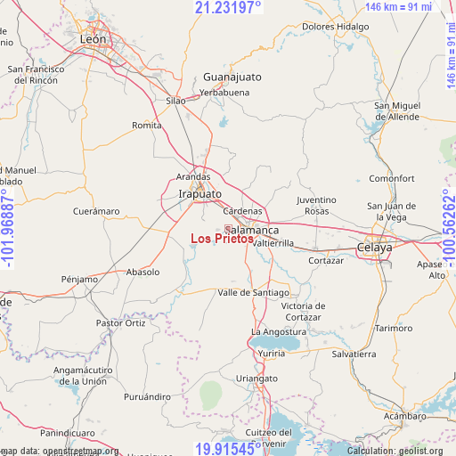
Los Prietos GPS coordinates[2]
20° 34' 30.468" North, 101° 15' 56.664" West
| Map corner | latitude | longitude |
|---|---|---|
| Upper-left | 21.23197°, | -101.96887° |
| Center: | 20.57513°, | -101.26574° |
| Lower-right: | 19.91545°, | -100.56262° |
| Map W x H: | 146.4×146.4 km | = 91×91mi |
| max Lat: | 32.7° ⇑30.5% North |
| Los Prietos: | 20.57513° |
| min Lat: | ⇓69.5% South 14.53588° |
| min Long | Los Prietos | max Long |
| -117.105° | -101.26574° | -86.73105° |
| W 24.6%⇐ | ⇒75.4% E |
Elevation
Elevation of Los Prietos is 1715 m = 5627 ft, and this is 461.3 m = 1513 ft above average elevation for this country.
| Max E: |
3497 m = 11473 ft | 40.7% |
| Los Prietos | 1715 m 5627 ft | |
| Avg. | 1253.7 m = 4113 ft | |
Min E: |
-1 m = -3 ft | 59.3% |
See also: Mexico elevation on elevation.city.
Geographical zone
Los Prietos is located in North Torrid zone (between Equator and Tropic of Cancer). Distance of this Northern Tropic circle is 318.2 km =197.7 mi to North.| Distance of | km | miles | from Los Prietos |
|---|---|---|---|
| North Pole | 7719.3 | 4796.5 | to North |
| Arctic Circle | 5113.4 | 3177.3 | to North |
| Tropic Cancer | 318.2 | 197.7 | to North |
| Equator | 2287.7 | 1421.5 | to South |


Nearby cities:
15 places around Los Prietos: (largest is in red/bold)
• Cerro Prieto
8.1 km =5 mi,  218°
218°
• Cuarta Brigada
5.4 km =3.4 mi,  344°
344°
• Cárdenas
7.7 km =4.8 mi,  37°
37°
• El Tambor
9.4 km =5.8 mi,  203°
203°
• La Capilla
4.1 km =2.5 mi,  240°
240°
• La Luz
9.1 km =5.7 mi,  105°
105°
• La Soledad
6.6 km =4.1 mi, 242°
• Loma Pelada
3 km =1.9 mi,  263°
263°
• Palo Blanco
9.7 km =6 mi,  140°
140°
• Salamanca
7.7 km =4.8 mi,  92°
92°
• San Antonio el Chico
6.2 km =3.9 mi, 342°
• San Juan de Razos
4.5 km =2.8 mi,  120°
120°
• San Roque
8.4 km =5.2 mi,  289°
289°
• San Vicente de Flores
5.3 km =3.3 mi,  14°
14°
• Santo Domingo
7.6 km =4.7 mi,  149°
149°
Sources, notices
• [Note1] Compared only with cities in Mexico existing in our database
• [Src1] Map data: © OpenStreetMap contributors (CC-BY-SA)
• [Src2] Other city data from geonames.org with taken over terms of usage.
• [Src3] Geographical zone / Annual Mean Temperature by Robert A. Rohde @ Wikipedia
