La Capilla geodata
La Capilla (Guanajuato) is a populated place; located in Mexico in America/Mexico_City (GMT-6) time zone. With population of 1,541 people, there are 5600 cities with bigger population in this country. Compared to other cities in Mexico, 69.1% of cities are located further ↓South; 75.7% of cities are located further →East and 59.1% of cities have lower elevation than La Capilla. Note1


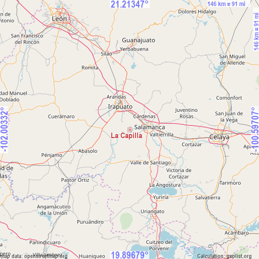
La Capilla GPS coordinates[2]
20° 33' 23.58" North, 101° 18' 0.684" West
| Map corner | latitude | longitude |
|---|---|---|
| Upper-left | 21.21347°, | -102.00332° |
| Center: | 20.55655°, | -101.30019° |
| Lower-right: | 19.89679°, | -100.59707° |
| Map W x H: | 146.4×146.4 km | = 91×91mi |
| max Lat: | 32.7° ⇑30.9% North |
| La Capilla: | 20.55655° |
| min Lat: | ⇓69.1% South 14.53588° |
| min Long | La Capilla | max Long |
| -117.105° | -101.30019° | -86.73105° |
| W 24.3%⇐ | ⇒75.7% E |
Elevation
Elevation of La Capilla is 1710 m = 5610 ft, and this is 456.3 m = 1497 ft above average elevation for this country.
| Max E: |
3497 m = 11473 ft | 40.9% |
| La Capilla | 1710 m 5610 ft | |
| Avg. | 1253.7 m = 4113 ft | |
Min E: |
-1 m = -3 ft | 59.1% |
See also: Mexico elevation on elevation.city.
Geographical zone
La Capilla is located in North Torrid zone (between Equator and Tropic of Cancer). Distance of this Northern Tropic circle is 320.2 km =199 mi to North.| Distance of | km | miles | from La Capilla |
|---|---|---|---|
| North Pole | 7721.4 | 4797.9 | to North |
| Arctic Circle | 5115.5 | 3178.6 | to North |
| Tropic Cancer | 320.2 | 199 | to North |
| Equator | 2285.7 | 1420.3 | to South |


Nearby cities:
15 places around La Capilla: (largest is in red/bold)
• Cerro Prieto
4.6 km =2.9 mi,  198°
198°
• Cuarta Brigada
7.6 km =4.7 mi,  16°
16°
• El Tambor
6.5 km =4 mi,  181°
181°
• La Soledad
2.5 km =1.6 mi,  245°
245°
• Loma Pelada
1.9 km =1.2 mi, 19°
• Los Prietos
4.1 km =2.5 mi,  60°
60°
• Pueblo Nuevo
8.2 km =5.1 mi,  244°
244°
• San Antonio el Chico
8.1 km =5 mi,  12°
12°
• San Guillermo
8.9 km =5.5 mi,  228°
228°
• San Juan de Razos
7.5 km =4.7 mi,  91°
91°
• San Roque
6.5 km =4 mi,  317°
317°
• San Vicente de Flores
8.8 km =5.5 mi,  34°
34°
• Santo Domingo
8.7 km =5.4 mi,  121°
121°
• Tomelopitos
8.3 km =5.2 mi,  300°
300°
• Villa de Guadalupe
8.6 km =5.3 mi,  277°
277°
Sources, notices
• [Note1] Compared only with cities in Mexico existing in our database
• [Src1] Map data: © OpenStreetMap contributors (CC-BY-SA)
• [Src2] Other city data from geonames.org with taken over terms of usage.
• [Src3] Geographical zone / Annual Mean Temperature by Robert A. Rohde @ Wikipedia
