Cuarta Brigada geodata
Cuarta Brigada (Guanajuato) is a populated place; located in Mexico in America/Mexico_City (GMT-6) time zone. With population of 2,973 people, there are 3012 cities with bigger population in this country. Compared to other cities in Mexico, 70.4% of cities are located further ↓South; 75.5% of cities are located further →East and 59.2% of cities have lower elevation than Cuarta Brigada. Note1


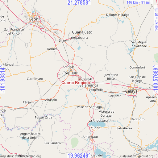
Cuarta Brigada GPS coordinates[2]
20° 37' 18.984" North, 101° 16' 48.036" West
| Map corner | latitude | longitude |
|---|---|---|
| Upper-left | 21.27858°, | -101.98314° |
| Center: | 20.62194°, | -101.28001° |
| Lower-right: | 19.96246°, | -100.57689° |
| Map W x H: | 146.3×146.3 km | = 90.9×90.9mi |
| max Lat: | 32.7° ⇑29.6% North |
| Cuarta Brigada: | 20.62194° |
| min Lat: | ⇓70.4% South 14.53588° |
| min Long | Cuarta Brigada | max Long |
| -117.105° | -101.28001° | -86.73105° |
| W 24.5%⇐ | ⇒75.5% E |
Elevation
Elevation of Cuarta Brigada is 1714 m = 5623 ft, and this is 460.3 m = 1510 ft above average elevation for this country.
| Max E: |
3497 m = 11473 ft | 40.8% |
| Cuarta Brigada | 1714 m 5623 ft | |
| Avg. | 1253.7 m = 4113 ft | |
Min E: |
-1 m = -3 ft | 59.2% |
See also: Mexico elevation on elevation.city.
Geographical zone
Cuarta Brigada is located in North Torrid zone (between Equator and Tropic of Cancer). Distance of this Northern Tropic circle is 313 km =194.5 mi to North.| Distance of | km | miles | from Cuarta Brigada |
|---|---|---|---|
| North Pole | 7714.1 | 4793.3 | to North |
| Arctic Circle | 5108.2 | 3174.1 | to North |
| Tropic Cancer | 313 | 194.5 | to North |
| Equator | 2292.9 | 1424.7 | to South |


Nearby cities:
15 places around Cuarta Brigada: (largest is in red/bold)
• Carrizal Grande
9.8 km =6.1 mi,  343°
343°
• Cárdenas
6.3 km =3.9 mi,  81°
81°
• El Carmen
9.8 km =6.1 mi,  281°
281°
• Irapuato
10 km =6.2 mi,  307°
307°
• La Capilla
7.6 km =4.7 mi,  196°
196°
• La Soledad
9.4 km =5.8 mi,  207°
207°
• La Zahúrda
9 km =5.6 mi, 281°
• Loma Pelada
5.7 km =3.5 mi,  194°
194°
• Los Prietos
5.4 km =3.4 mi,  164°
164°
• San Antonio el Chico
0.8 km =0.5 mi,  330°
330°
• San José Temascatío
8 km =5 mi,  14°
14°
• San Juan de Razos
9.2 km =5.7 mi,  144°
144°
• San Roque
6.9 km =4.3 mi,  248°
248°
• San Vicente de Flores
2.8 km =1.7 mi,  90°
90°
• Tomelopitos
9.7 km =6 mi, 251°
Sources, notices
• [Note1] Compared only with cities in Mexico existing in our database
• [Src1] Map data: © OpenStreetMap contributors (CC-BY-SA)
• [Src2] Other city data from geonames.org with taken over terms of usage.
• [Src3] Geographical zone / Annual Mean Temperature by Robert A. Rohde @ Wikipedia
