Estación Corralejo geodata
Estación Corralejo (Guanajuato) is a populated place; located in Mexico in America/Mexico_City (GMT-6) time zone. With population of 1,008 people, there are 8648 cities with bigger population in this country. Compared to other cities in Mexico, 67.1% of cities are located further ↓South; 78.3% of cities are located further →East and 58.2% of cities have lower elevation than Estación Corralejo. Note1


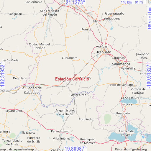
Estación Corralejo GPS coordinates[2]
20° 28' 12" North, 101° 36' 59.004" West
| Map corner | latitude | longitude |
|---|---|---|
| Upper-left | 21.1273°, | -102.31952° |
| Center: | 20.47°, | -101.61639° |
| Lower-right: | 19.80987°, | -100.91327° |
| Map W x H: | 146.5×146.5 km | = 91×91mi |
| max Lat: | 32.7° ⇑32.9% North |
| Estación Corralejo: | 20.47° |
| min Lat: | ⇓67.1% South 14.53588° |
| min Long | Estación Corra | max Long |
| -117.105° | -101.61639° | -86.73105° |
| W 21.7%⇐ | ⇒78.3% E |
Elevation
Elevation of Estación Corralejo is 1694 m = 5558 ft, and this is 440.3 m = 1445 ft above average elevation for this country.
| Max E: |
3497 m = 11473 ft | 41.8% |
| Estación Corralejo | 1694 m 5558 ft | |
| Avg. | 1253.7 m = 4113 ft | |
Min E: |
-1 m = -3 ft | 58.2% |
See also: Mexico elevation on elevation.city.
Geographical zone
Estación Corralejo is located in North Torrid zone (between Equator and Tropic of Cancer). Distance of this Northern Tropic circle is 329.9 km =205 mi to North.| Distance of | km | miles | from Estación Corralejo |
|---|---|---|---|
| North Pole | 7731 | 4803.8 | to North |
| Arctic Circle | 5125.1 | 3184.6 | to North |
| Tropic Cancer | 329.9 | 205 | to North |
| Equator | 2276.1 | 1414.3 | to South |


Nearby cities:
15 places around Estación Corralejo: (largest is in red/bold)
• Abasolo
9.2 km =5.7 mi,  104°
104°
• Concepción de Ruiz
9.3 km =5.8 mi,  180°
180°
• Corralejo de Hidalgo
4.3 km =2.7 mi,  339°
339°
• El Novillero
9.5 km =5.9 mi,  152°
152°
• El Tule
6.6 km =4.1 mi,  17°
17°
• Estación Abasolo
5.9 km =3.7 mi,  49°
49°
• Huitzatarito
5.4 km =3.4 mi,  62°
62°
• La Granjena
9.5 km =5.9 mi,  208°
208°
• Las Cruces
8.2 km =5.1 mi,  32°
32°
• Magallanes
8.4 km =5.2 mi,  264°
264°
• Purísima de Ramírez (Los Oriones)
4.8 km =3 mi, 210°
• San Gabriel y San Ignacio
3.4 km =2.1 mi,  165°
165°
• San Gregorio
8.6 km =5.3 mi,  351°
351°
• Tamazula
7.3 km =4.5 mi,  115°
115°
• Zapote de Cestao
6.4 km =4 mi,  283°
283°
Sources, notices
• [Note1] Compared only with cities in Mexico existing in our database
• [Src1] Map data: © OpenStreetMap contributors (CC-BY-SA)
• [Src2] Other city data from geonames.org with taken over terms of usage.
• [Src3] Geographical zone / Annual Mean Temperature by Robert A. Rohde @ Wikipedia
