La Ladera geodata
La Ladera (Guanajuato) is a populated place; located in Mexico in America/Mexico_City (GMT-6) time zone. With population of 532 people, there are 15923 cities with bigger population in this country. Compared to other cities in Mexico, 72.7% of cities are located further ↓South; 80.9% of cities are located further →East and 62.6% of cities have lower elevation than La Ladera. Note1


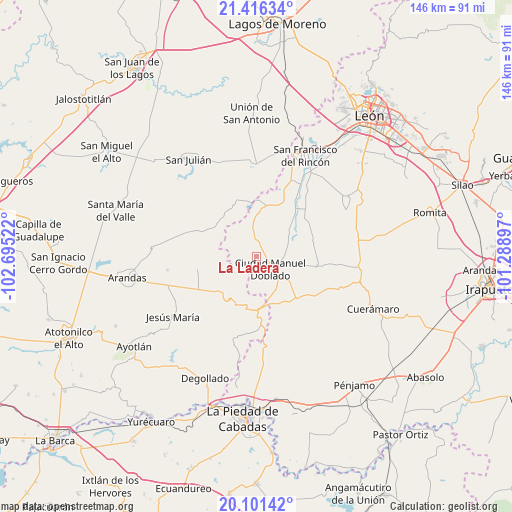
La Ladera GPS coordinates[2]
20° 45' 37.116" North, 101° 59' 31.524" West
| Map corner | latitude | longitude |
|---|---|---|
| Upper-left | 21.41634°, | -102.69522° |
| Center: | 20.76031°, | -101.99209° |
| Lower-right: | 20.10142°, | -101.28897° |
| Map W x H: | 146.2×146.2 km | = 90.8×90.8mi |
| max Lat: | 32.7° ⇑27.3% North |
| La Ladera: | 20.76031° |
| min Lat: | ⇓72.7% South 14.53588° |
| min Long | La Ladera | max Long |
| -117.105° | -101.99209° | -86.73105° |
| W 19.1%⇐ | ⇒80.9% E |
Elevation
Elevation of La Ladera is 1771 m = 5810 ft, and this is 517.3 m = 1697 ft above average elevation for this country.
| Max E: |
3497 m = 11473 ft | 37.4% |
| La Ladera | 1771 m 5810 ft | |
| Avg. | 1253.7 m = 4113 ft | |
Min E: |
-1 m = -3 ft | 62.6% |
See also: Mexico elevation on elevation.city.
Geographical zone
La Ladera is located in North Torrid zone (between Equator and Tropic of Cancer). Distance of this Northern Tropic circle is 297.6 km =184.9 mi to North.| Distance of | km | miles | from La Ladera |
|---|---|---|---|
| North Pole | 7698.7 | 4783.7 | to North |
| Arctic Circle | 5092.8 | 3164.5 | to North |
| Tropic Cancer | 297.6 | 184.9 | to North |
| Equator | 2308.3 | 1434.3 | to South |


Nearby cities:
15 places around La Ladera: (largest is in red/bold)
• Allende
10.7 km =6.6 mi,  245°
245°
• Calzada del Tepozán
11.6 km =7.2 mi,  102°
102°
• Ciudad Manuel Doblado
5.4 km =3.4 mi,  130°
130°
• El Charcón
8.9 km =5.5 mi,  108°
108°
• El Tecolote
15.5 km =9.6 mi,  27°
27°
• El Tecuán
15.2 km =9.4 mi,  61°
61°
• El Toro
11.7 km =7.3 mi,  49°
49°
• Frías
4.4 km =2.7 mi,  354°
354°
• Guadalupe de Jalpa
11.2 km =7 mi,  7°
7°
• Guayabo de Santa Rita
11.5 km =7.1 mi, 127°
• Jalpa de Cánovas
13.4 km =8.3 mi,  3°
3°
• La Calzada de la Merced
13.6 km =8.5 mi,  82°
82°
• Maravillas
9.1 km =5.7 mi, 100°
• Rancho Nuevo de Atotonilquillo
13.8 km =8.6 mi, 133°
• San Ángel
17.5 km =10.9 mi, 25°
Sources, notices
• [Note1] Compared only with cities in Mexico existing in our database
• [Src1] Map data: © OpenStreetMap contributors (CC-BY-SA)
• [Src2] Other city data from geonames.org with taken over terms of usage.
• [Src3] Geographical zone / Annual Mean Temperature by Robert A. Rohde @ Wikipedia
