Los Desmontes geodata
Los Desmontes (Guanajuato) is a populated place; located in Mexico in America/Mexico_City (GMT-6) time zone. With population of 1,016 people, there are 8570 cities with bigger population in this country. Compared to other cities in Mexico, 56.1% of cities are located further ↓South; 71.4% of cities are located further →East and 76.3% of cities have lower elevation than Los Desmontes. Note1


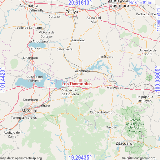
Los Desmontes GPS coordinates[2]
19° 57' 23.832" North, 100° 44' 21.012" West
| Map corner | latitude | longitude |
|---|---|---|
| Upper-left | 20.61613°, | -101.4423° |
| Center: | 19.95662°, | -100.73917° |
| Lower-right: | 19.29435°, | -100.03605° |
| Map W x H: | 147×147 km | = 91.3×91.3mi |
| max Lat: | 32.7° ⇑43.9% North |
| Los Desmontes: | 19.95662° |
| min Lat: | ⇓56.1% South 14.53588° |
| min Long | Los Desmontes | max Long |
| -117.105° | -100.73917° | -86.73105° |
| W 28.6%⇐ | ⇒71.4% E |
Elevation
Elevation of Los Desmontes is 2054 m = 6739 ft, and this is 800.3 m = 2626 ft above average elevation for this country.
| Max E: |
3497 m = 11473 ft | 23.7% |
| Los Desmontes | 2054 m 6739 ft | |
| Avg. | 1253.7 m = 4113 ft | |
Min E: |
-1 m = -3 ft | 76.3% |
See also: Mexico elevation on elevation.city.
Geographical zone
Los Desmontes is located in North Torrid zone (between Equator and Tropic of Cancer). Distance of this Northern Tropic circle is 387 km =240.5 mi to North.| Distance of | km | miles | from Los Desmontes |
|---|---|---|---|
| North Pole | 7788.1 | 4839.3 | to North |
| Arctic Circle | 5182.2 | 3220.1 | to North |
| Tropic Cancer | 387 | 240.5 | to North |
| Equator | 2219 | 1378.8 | to South |


Nearby cities:
15 places around Los Desmontes: (largest is in red/bold)
• Acámbaro
8.4 km =5.2 mi,  12°
12°
• Agua Caliente
11.4 km =7.1 mi,  35°
35°
• Andocutín
13.2 km =8.2 mi,  269°
269°
• Araró
10.3 km =6.4 mi,  240°
240°
• Arroyo Colorado
13.5 km =8.4 mi,  64°
64°
• Buenavista
10.9 km =6.8 mi,  109°
109°
• El Rodeo
12.1 km =7.5 mi,  87°
87°
• La Merced
11 km =6.8 mi,  317°
317°
• San Ildefonso
13 km =8.1 mi,  104°
104°
• San Juan Jaripeo
5.9 km =3.7 mi,  337°
337°
• San Miguel
13.3 km =8.3 mi,  46°
46°
• San Miguel Taimeo
14.1 km =8.8 mi,  205°
205°
• Solís
12.2 km =7.6 mi,  30°
30°
• Ucareo
8.5 km =5.3 mi,  139°
139°
• Zinapécuaro
14.2 km =8.8 mi,  221°
221°
Sources, notices
• [Note1] Compared only with cities in Mexico existing in our database
• [Src1] Map data: © OpenStreetMap contributors (CC-BY-SA)
• [Src2] Other city data from geonames.org with taken over terms of usage.
• [Src3] Geographical zone / Annual Mean Temperature by Robert A. Rohde @ Wikipedia
