Ucareo geodata
Ucareo (Michoacán) is a populated place; located in Mexico in America/Mexico_City (GMT-6) time zone. With population of 2,284 people, there are 3855 cities with bigger population in this country. Compared to other cities in Mexico, 55% of cities are located further ↓South; 71% of cities are located further →East and 93.6% of cities have lower elevation than Ucareo. Note1


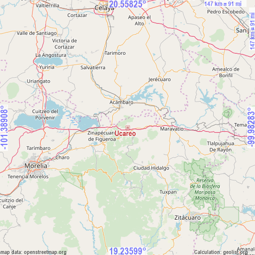
Ucareo GPS coordinates[2]
19° 53' 54.6" North, 100° 41' 9.42" West
| Map corner | latitude | longitude |
|---|---|---|
| Upper-left | 20.55825°, | -101.38908° |
| Center: | 19.8985°, | -100.68595° |
| Lower-right: | 19.23599°, | -99.98283° |
| Map W x H: | 147×147 km | = 91.3×91.3mi |
| max Lat: | 32.7° ⇑45% North |
| Ucareo: | 19.8985° |
| min Lat: | ⇓55% South 14.53588° |
| min Long | Ucareo | max Long |
| -117.105° | -100.68595° | -86.73105° |
| W 29%⇐ | ⇒71% E |
Elevation
Elevation of Ucareo is 2553 m = 8376 ft, and this is 1299.3 m = 4263 ft above average elevation for this country.
| Max E: |
3497 m = 11473 ft | 6.4% |
| Ucareo | 2553 m 8376 ft | |
| Avg. | 1253.7 m = 4113 ft | |
Min E: |
-1 m = -3 ft | 93.6% |
See also: Mexico elevation on elevation.city.
Geographical zone
Ucareo is located in North Torrid zone (between Equator and Tropic of Cancer). Distance of this Northern Tropic circle is 393.4 km =244.4 mi to North.| Distance of | km | miles | from Ucareo |
|---|---|---|---|
| North Pole | 7794.6 | 4843.3 | to North |
| Arctic Circle | 5188.7 | 3224.1 | to North |
| Tropic Cancer | 393.4 | 244.4 | to North |
| Equator | 2212.5 | 1374.8 | to South |


Nearby cities:
15 places around Ucareo: (largest is in red/bold)
• Acámbaro
15.2 km =9.4 mi,  345°
345°
• Araró
14.6 km =9.1 mi,  275°
275°
• Arroyo Colorado
13.9 km =8.6 mi,  28°
28°
• Buenavista
5.4 km =3.4 mi,  59°
59°
• El Rodeo
9.6 km =6 mi,  42°
42°
• Heriberto Jara (La Presa)
9 km =5.6 mi,  80°
80°
• Huajúmbaro
9.1 km =5.7 mi,  110°
110°
• Las Palomas
14 km =8.7 mi,  124°
124°
• Los Desmontes
8.5 km =5.3 mi,  319°
319°
• Ojo de Agua de Bucio
13.8 km =8.6 mi,  198°
198°
• San Ildefonso
7.7 km =4.8 mi,  65°
65°
• San Juan Jaripeo
14.3 km =8.9 mi,  326°
326°
• San Miguel Curinhuato
14.6 km =9.1 mi,  48°
48°
• San Miguel Taimeo
13.2 km =8.2 mi,  242°
242°
• Santiago Puriatzícuaro
10.3 km =6.4 mi,  99°
99°
Sources, notices
• [Note1] Compared only with cities in Mexico existing in our database
• [Src1] Map data: © OpenStreetMap contributors (CC-BY-SA)
• [Src2] Other city data from geonames.org with taken over terms of usage.
• [Src3] Geographical zone / Annual Mean Temperature by Robert A. Rohde @ Wikipedia
