Agua Caliente geodata
Agua Caliente (Guanajuato) is a populated place; located in Mexico in America/Mexico_City (GMT-6) time zone. With population of 700 people, there are 12436 cities with bigger population in this country. Compared to other cities in Mexico, 57.8% of cities are located further ↓South; 70.9% of cities are located further →East and 66.7% of cities have lower elevation than Agua Caliente. Note1


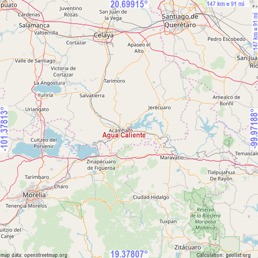
Agua Caliente GPS coordinates[2]
20° 2' 24" North, 100° 40' 30" West
| Map corner | latitude | longitude |
|---|---|---|
| Upper-left | 20.69915°, | -101.37813° |
| Center: | 20.04°, | -100.675° |
| Lower-right: | 19.37807°, | -99.97188° |
| Map W x H: | 146.9×146.9 km | = 91.3×91.3mi |
| max Lat: | 32.7° ⇑42.2% North |
| Agua Caliente: | 20.04° |
| min Lat: | ⇓57.8% South 14.53588° |
| min Long | Agua Caliente | max Long |
| -117.105° | -100.675° | -86.73105° |
| W 29.1%⇐ | ⇒70.9% E |
Elevation
Elevation of Agua Caliente is 1864 m = 6115 ft, and this is 610.3 m = 2002 ft above average elevation for this country.
| Max E: |
3497 m = 11473 ft | 33.3% |
| Agua Caliente | 1864 m 6115 ft | |
| Avg. | 1253.7 m = 4113 ft | |
Min E: |
-1 m = -3 ft | 66.7% |
See also: Mexico elevation on elevation.city.
Geographical zone
Agua Caliente is located in North Torrid zone (between Equator and Tropic of Cancer). Distance of this Northern Tropic circle is 377.7 km =234.7 mi to North.| Distance of | km | miles | from Agua Caliente |
|---|---|---|---|
| North Pole | 7778.8 | 4833.5 | to North |
| Arctic Circle | 5172.9 | 3214.3 | to North |
| Tropic Cancer | 377.7 | 234.7 | to North |
| Equator | 2228.2 | 1384.5 | to South |


Nearby cities:
15 places around Agua Caliente: (largest is in red/bold)
• Acámbaro
5 km =3.1 mi,  258°
258°
• Arroyo Colorado
6.5 km =4 mi,  122°
122°
• Arroyo de la Luna
8.8 km =5.5 mi,  102°
102°
• El Maguey
7 km =4.3 mi,  350°
350°
• El Rodeo
10.2 km =6.3 mi,  148°
148°
• Jaral del Refugio
9.7 km =6 mi,  329°
329°
• La Encarnación
5.5 km =3.4 mi,  48°
48°
• Los Desmontes
11.4 km =7.1 mi,  215°
215°
• San Cayetano
4.7 km =2.9 mi,  21°
21°
• San Juan Jaripeo
9.7 km =6 mi,  247°
247°
• San Juan Viejo
9.8 km =6.1 mi,  307°
307°
• San Miguel
2.9 km =1.8 mi,  90°
90°
• San Miguel Curinhuato
11.4 km =7.1 mi, 121°
• Santiaguillo
8.5 km =5.3 mi, 22°
• Solís
1.3 km =0.8 mi,  341°
341°
Sources, notices
• [Note1] Compared only with cities in Mexico existing in our database
• [Src1] Map data: © OpenStreetMap contributors (CC-BY-SA)
• [Src2] Other city data from geonames.org with taken over terms of usage.
• [Src3] Geographical zone / Annual Mean Temperature by Robert A. Rohde @ Wikipedia
