Peralta geodata
Peralta (Guanajuato) is a populated place; located in Mexico in America/Mexico_City (GMT-6) time zone. With population of 1,134 people, there are 7651 cities with bigger population in this country. Compared to other cities in Mexico, 67.2% of cities are located further ↓South; 76.5% of cities are located further →East and 59.3% of cities have lower elevation than Peralta. Note1


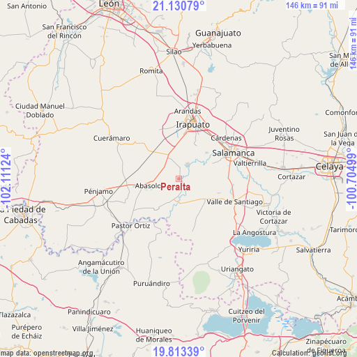
Peralta GPS coordinates[2]
20° 28' 24.6" North, 101° 24' 29.196" West
| Map corner | latitude | longitude |
|---|---|---|
| Upper-left | 21.13079°, | -102.11124° |
| Center: | 20.4735°, | -101.40811° |
| Lower-right: | 19.81339°, | -100.70499° |
| Map W x H: | 146.5×146.5 km | = 91×91mi |
| max Lat: | 32.7° ⇑32.8% North |
| Peralta: | 20.4735° |
| min Lat: | ⇓67.2% South 14.53588° |
| min Long | Peralta | max Long |
| -117.105° | -101.40811° | -86.73105° |
| W 23.5%⇐ | ⇒76.5% E |
Elevation
Elevation of Peralta is 1715 m = 5627 ft, and this is 461.3 m = 1513 ft above average elevation for this country.
| Max E: |
3497 m = 11473 ft | 40.7% |
| Peralta | 1715 m 5627 ft | |
| Avg. | 1253.7 m = 4113 ft | |
Min E: |
-1 m = -3 ft | 59.3% |
See also: Mexico elevation on elevation.city.
Geographical zone
Peralta is located in North Torrid zone (between Equator and Tropic of Cancer). Distance of this Northern Tropic circle is 329.5 km =204.7 mi to North.| Distance of | km | miles | from Peralta |
|---|---|---|---|
| North Pole | 7730.6 | 4803.6 | to North |
| Arctic Circle | 5124.7 | 3184.3 | to North |
| Tropic Cancer | 329.5 | 204.7 | to North |
| Equator | 2276.4 | 1414.5 | to South |


Nearby cities:
15 places around Peralta: (largest is in red/bold)
• Boquillas
6.9 km =4.3 mi,  202°
202°
• La Tinaja de Negrete
6.2 km =3.9 mi,  250°
250°
• Labor de Peralta
7.2 km =4.5 mi,  180°
180°
• Munguía
9.3 km =5.8 mi,  320°
320°
• Noria de Mosqueda
6.6 km =4.1 mi,  85°
85°
• Piedras Negras
5.1 km =3.2 mi,  160°
160°
• Pueblo Nuevo
6.9 km =4.3 mi,  33°
33°
• Rincón de Alonso Sánchez
2.1 km =1.3 mi,  80°
80°
• San Bernardo Peña Blanca
7.9 km =4.9 mi,  260°
260°
• San Cristóbal
9.2 km =5.7 mi,  173°
173°
• San Guillermo
5.6 km =3.5 mi,  54°
54°
• San Isidro
9.1 km =5.7 mi, 262°
• San Miguel del Brete
9.3 km =5.8 mi,  339°
339°
• Santa Bárbara
6.1 km =3.8 mi, 87°
• Zapote de Peralta
2.9 km =1.8 mi,  151°
151°
Sources, notices
• [Note1] Compared only with cities in Mexico existing in our database
• [Src1] Map data: © OpenStreetMap contributors (CC-BY-SA)
• [Src2] Other city data from geonames.org with taken over terms of usage.
• [Src3] Geographical zone / Annual Mean Temperature by Robert A. Rohde @ Wikipedia
