Zapote de Peralta geodata
Zapote de Peralta (Guanajuato) is a populated place; located in Mexico in America/Mexico_City (GMT-6) time zone. With population of 1,307 people, there are 6636 cities with bigger population in this country. Compared to other cities in Mexico, 66.7% of cities are located further ↓South; 76.4% of cities are located further →East and 59.1% of cities have lower elevation than Zapote de Peralta. Note1


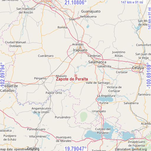
Zapote de Peralta GPS coordinates[2]
20° 27' 2.448" North, 101° 23' 41.316" West
| Map corner | latitude | longitude |
|---|---|---|
| Upper-left | 21.10806°, | -102.09794° |
| Center: | 20.45068°, | -101.39481° |
| Lower-right: | 19.79047°, | -100.69169° |
| Map W x H: | 146.5×146.5 km | = 91×91mi |
| max Lat: | 32.7° ⇑33.3% North |
| Zapote de Peralta: | 20.45068° |
| min Lat: | ⇓66.7% South 14.53588° |
| min Long | Zapote de Peral | max Long |
| -117.105° | -101.39481° | -86.73105° |
| W 23.6%⇐ | ⇒76.4% E |
Elevation
Elevation of Zapote de Peralta is 1710 m = 5610 ft, and this is 456.3 m = 1497 ft above average elevation for this country.
| Max E: |
3497 m = 11473 ft | 40.9% |
| Zapote de Peralta | 1710 m 5610 ft | |
| Avg. | 1253.7 m = 4113 ft | |
Min E: |
-1 m = -3 ft | 59.1% |
See also: Mexico elevation on elevation.city.
Geographical zone
Zapote de Peralta is located in North Torrid zone (between Equator and Tropic of Cancer). Distance of this Northern Tropic circle is 332 km =206.3 mi to North.| Distance of | km | miles | from Zapote de Peralta |
|---|---|---|---|
| North Pole | 7733.2 | 4805.2 | to North |
| Arctic Circle | 5127.3 | 3186 | to North |
| Tropic Cancer | 332 | 206.3 | to North |
| Equator | 2273.9 | 1412.9 | to South |


Nearby cities:
15 places around Zapote de Peralta: (largest is in red/bold)
• Boquillas
5.5 km =3.4 mi,  226°
226°
• Charco de Pantoja
8 km =5 mi,  148°
148°
• Guarapo
7.8 km =4.8 mi,  192°
192°
• La Tinaja de Negrete
7.2 km =4.5 mi,  273°
273°
• Labor de Peralta
4.9 km =3 mi,  197°
197°
• Noria de Mosqueda
6 km =3.7 mi,  59°
59°
• Peralta
2.9 km =1.8 mi,  331°
331°
• Piedras Negras
2.3 km =1.4 mi,  171°
171°
• Pueblo Nuevo
8.6 km =5.3 mi,  16°
16°
• Quiriceo
8.6 km =5.3 mi,  99°
99°
• Rincón de Alonso Sánchez
3 km =1.9 mi,  12°
12°
• San Cristóbal
6.6 km =4.1 mi,  182°
182°
• San Guillermo
6.6 km =4.1 mi,  28°
28°
• San José de Ayala
8.6 km =5.3 mi,  214°
214°
• Santa Bárbara
5.5 km =3.4 mi, 59°
Sources, notices
• [Note1] Compared only with cities in Mexico existing in our database
• [Src1] Map data: © OpenStreetMap contributors (CC-BY-SA)
• [Src2] Other city data from geonames.org with taken over terms of usage.
• [Src3] Geographical zone / Annual Mean Temperature by Robert A. Rohde @ Wikipedia
