La Tinaja de Negrete geodata
La Tinaja de Negrete (Guanajuato) is a populated place; located in Mexico in America/Mexico_City (GMT-6) time zone. With population of 559 people, there are 15266 cities with bigger population in this country. Compared to other cities in Mexico, 66.8% of cities are located further ↓South; 77.1% of cities are located further →East and 63.6% of cities have lower elevation than La Tinaja de Negrete. Note1


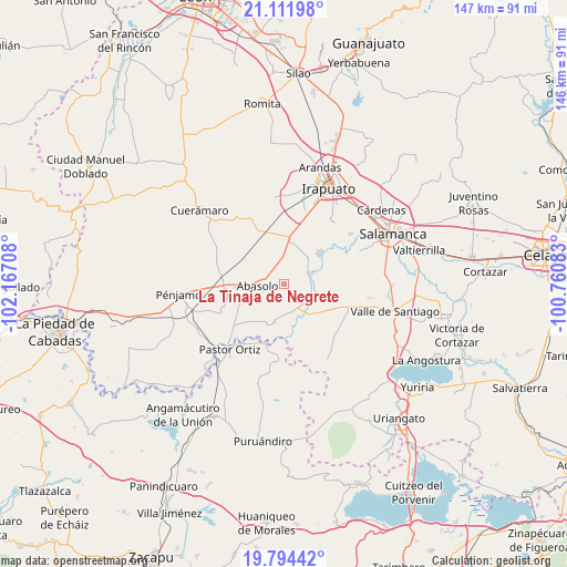
La Tinaja de Negrete GPS coordinates[2]
20° 27' 16.596" North, 101° 27' 50.22" West
| Map corner | latitude | longitude |
|---|---|---|
| Upper-left | 21.11198°, | -102.16708° |
| Center: | 20.45461°, | -101.46395° |
| Lower-right: | 19.79442°, | -100.76083° |
| Map W x H: | 146.5×146.5 km | = 91×91mi |
| max Lat: | 32.7° ⇑33.2% North |
| La Tinaja de Negrete: | 20.45461° |
| min Lat: | ⇓66.8% South 14.53588° |
| min Long | La Tinaja de Ne | max Long |
| -117.105° | -101.46395° | -86.73105° |
| W 22.9%⇐ | ⇒77.1% E |
Elevation
Elevation of La Tinaja de Negrete is 1791 m = 5876 ft, and this is 537.3 m = 1763 ft above average elevation for this country.
| Max E: |
3497 m = 11473 ft | 36.4% |
| La Tinaja de Negrete | 1791 m 5876 ft | |
| Avg. | 1253.7 m = 4113 ft | |
Min E: |
-1 m = -3 ft | 63.6% |
See also: Mexico elevation on elevation.city.
Geographical zone
La Tinaja de Negrete is located in North Torrid zone (between Equator and Tropic of Cancer). Distance of this Northern Tropic circle is 331.6 km =206 mi to North.| Distance of | km | miles | from La Tinaja de Negrete |
|---|---|---|---|
| North Pole | 7732.7 | 4804.9 | to North |
| Arctic Circle | 5126.8 | 3185.6 | to North |
| Tropic Cancer | 331.6 | 206 | to North |
| Equator | 2274.3 | 1413.2 | to South |


Nearby cities:
15 places around La Tinaja de Negrete: (largest is in red/bold)
• Abasolo
7 km =4.3 mi,  265°
265°
• Boquillas
5.3 km =3.3 mi,  143°
143°
• Guarapo
9.7 km =6 mi,  145°
145°
• Labor de Peralta
7.7 km =4.8 mi,  131°
131°
• Munguía
9.2 km =5.7 mi,  359°
359°
• Otates
6.3 km =3.9 mi,  197°
197°
• Peralta
6.2 km =3.9 mi,  70°
70°
• Piedras Negras
8 km =5 mi,  109°
109°
• Rincón de Alonso Sánchez
8.2 km =5.1 mi, 72°
• San Bernardo Peña Blanca
2.1 km =1.3 mi,  292°
292°
• San Isidro
3.3 km =2.1 mi, 287°
• San José de Ayala
7.9 km =4.9 mi,  162°
162°
• San José de González
8.1 km =5 mi,  312°
312°
• Tamazula
9.4 km =5.8 mi,  261°
261°
• Zapote de Peralta
7.2 km =4.5 mi,  93°
93°
Sources, notices
• [Note1] Compared only with cities in Mexico existing in our database
• [Src1] Map data: © OpenStreetMap contributors (CC-BY-SA)
• [Src2] Other city data from geonames.org with taken over terms of usage.
• [Src3] Geographical zone / Annual Mean Temperature by Robert A. Rohde @ Wikipedia
