San Miguel el Alto (San Miguelito) geodata
San Miguel el Alto (San Miguelito) (Guanajuato) is a populated place; located in Mexico in America/Mexico_City (GMT-6) time zone. With population of 608 people, there are 14173 cities with bigger population in this country. Compared to other cities in Mexico, 61.6% of cities are located further ↓South; 74.8% of cities are located further →East and 63.7% of cities have lower elevation than San Miguel el Alto (San Miguelito). Note1
Current local time in San Miguel el Alto (San Miguelito):
08:28 AM, WednesdayDifference from your time zone: hours


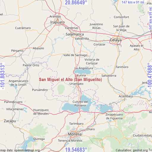
San Miguel el Alto (San Miguelito) GPS coordinates[2]
20° 12' 29.016" North, 101° 10' 48" West
| Map corner | latitude | longitude |
|---|---|---|
| Upper-left | 20.86649°, | -101.88313° |
| Center: | 20.20806°, | -101.18° |
| Lower-right: | 19.54683°, | -100.47688° |
| Map W x H: | 146.7×146.7 km | = 91.2×91.2mi |
| max Lat: | 32.7° ⇑38.4% North |
| San Miguel el Alto (San Miguelito): | 20.20806° |
| min Lat: | ⇓61.6% South 14.53588° |
| min Long | San Miguel el A | max Long |
| -117.105° | -101.18° | -86.73105° |
| W 25.2%⇐ | ⇒74.8% E |
Elevation
Elevation of San Miguel el Alto (San Miguelito) is 1794 m = 5886 ft, and this is 540.3 m = 1773 ft above average elevation for this country.
| Max E: |
3497 m = 11473 ft | 36.3% |
| San Miguel el Alto (San Miguelito) | 1794 m 5886 ft | |
| Avg. | 1253.7 m = 4113 ft | |
Min E: |
-1 m = -3 ft | 63.7% |
See also: Mexico elevation on elevation.city.
Geographical zone
San Miguel el Alto (San Miguelito) is located in North Torrid zone (between Equator and Tropic of Cancer). Distance of this Northern Tropic circle is 359 km =223.1 mi to North.| Distance of | km | miles | from San Miguel el Alto (San Miguelito) |
|---|---|---|---|
| North Pole | 7760.1 | 4821.9 | to North |
| Arctic Circle | 5154.2 | 3202.7 | to North |
| Tropic Cancer | 359 | 223.1 | to North |
| Equator | 2246.9 | 1396.2 | to South |


Nearby cities:
15 places around San Miguel el Alto (San Miguelito): (largest is in red/bold)
• Cahuageo
9.1 km =5.7 mi,  34°
34°
• Colonia Juárez
7.8 km =4.8 mi,  154°
154°
• El Charco
8.8 km =5.5 mi,  142°
142°
• El Tigre
9.7 km =6 mi,  287°
287°
• Gervasio Mendoza
9.7 km =6 mi,  22°
22°
• La Angostura
10.6 km =6.6 mi,  43°
43°
• Las Misiones
5.4 km =3.4 mi,  168°
168°
• Monte de los Juárez
7.9 km =4.9 mi,  249°
249°
• Moroleón
9.2 km =5.7 mi,  187°
187°
• Ochomitas
3.2 km =2 mi,  302°
302°
• Parangarico
2.3 km =1.4 mi, 139°
• Porullo
9.8 km =6.1 mi,  117°
117°
• San Andrés Enguaro
6.1 km =3.8 mi,  255°
255°
• Uriangato
7.5 km =4.7 mi,  182°
182°
• Yuriria
5 km =3.1 mi,  86°
86°
Sources, notices
• [Note1] Compared only with cities in Mexico existing in our database
• [Src1] Map data: © OpenStreetMap contributors (CC-BY-SA)
• [Src2] Other city data from geonames.org with taken over terms of usage.
• [Src3] Geographical zone / Annual Mean Temperature by Robert A. Rohde @ Wikipedia
