La Tepuza geodata
La Tepuza (Michoacán) is a populated place; located in Mexico in America/Mexico_City (GMT-6) time zone. With population of 687 people, there are 12648 cities with bigger population in this country. Compared to other cities in Mexico, 61% of cities are located further ↓South; 80.5% of cities are located further →East and 58.1% of cities have lower elevation than La Tepuza. Note1


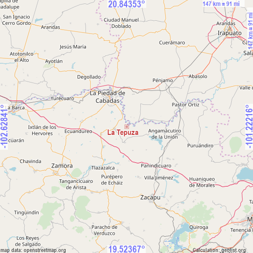
La Tepuza GPS coordinates[2]
20° 11' 6" North, 101° 55' 31.008" West
| Map corner | latitude | longitude |
|---|---|---|
| Upper-left | 20.84353°, | -102.62841° |
| Center: | 20.185°, | -101.92528° |
| Lower-right: | 19.52367°, | -101.22216° |
| Map W x H: | 146.8×146.8 km | = 91.2×91.2mi |
| max Lat: | 32.7° ⇑39% North |
| La Tepuza: | 20.185° |
| min Lat: | ⇓61% South 14.53588° |
| min Long | La Tepuza | max Long |
| -117.105° | -101.92528° | -86.73105° |
| W 19.5%⇐ | ⇒80.5% E |
Elevation
Elevation of La Tepuza is 1693 m = 5554 ft, and this is 439.3 m = 1441 ft above average elevation for this country.
| Max E: |
3497 m = 11473 ft | 41.9% |
| La Tepuza | 1693 m 5554 ft | |
| Avg. | 1253.7 m = 4113 ft | |
Min E: |
-1 m = -3 ft | 58.1% |
See also: Mexico elevation on elevation.city.
Geographical zone
La Tepuza is located in North Torrid zone (between Equator and Tropic of Cancer). Distance of this Northern Tropic circle is 361.6 km =224.7 mi to North.| Distance of | km | miles | from La Tepuza |
|---|---|---|---|
| North Pole | 7762.7 | 4823.5 | to North |
| Arctic Circle | 5156.8 | 3204.3 | to North |
| Tropic Cancer | 361.6 | 224.7 | to North |
| Equator | 2244.4 | 1394.6 | to South |


Nearby cities:
15 places around La Tepuza: (largest is in red/bold)
• Cerritos Blancos
6.3 km =3.9 mi,  23°
23°
• Corrales de Rábago
7.6 km =4.7 mi,  64°
64°
• Cruces de Rojas
8.3 km =5.2 mi,  25°
25°
• El Colorado
2.2 km =1.4 mi,  212°
212°
• El Palmito
3.7 km =2.3 mi,  324°
324°
• Guándaro
5.4 km =3.4 mi,  81°
81°
• La Lobera
11.2 km =7 mi,  8°
8°
• La Luz
6.3 km =3.9 mi,  150°
150°
• Numarán
8.3 km =5.2 mi,  341°
341°
• Patambarillo
9.3 km =5.8 mi,  127°
127°
• Penjamillo de Degollado
9 km =5.6 mi,  186°
186°
• San José de Rábago
3.9 km =2.4 mi, 126°
• Santa Fe del Río
10.5 km =6.5 mi, 78°
• Tirimácuaro (Valanciana)
9 km =5.6 mi,  168°
168°
• Zináparo
7.7 km =4.8 mi,  259°
259°
Sources, notices
• [Note1] Compared only with cities in Mexico existing in our database
• [Src1] Map data: © OpenStreetMap contributors (CC-BY-SA)
• [Src2] Other city data from geonames.org with taken over terms of usage.
• [Src3] Geographical zone / Annual Mean Temperature by Robert A. Rohde @ Wikipedia
