Tzitzio geodata
Tzitzio (Michoacán) is a seat of a second-order administrative division; located in Mexico in America/Mexico_City (GMT-6) time zone. With population of 1,072 people, there are 8140 cities with bigger population in this country. Compared to other cities in Mexico, 52.2% of cities are located further ↑North; 72.9% of cities are located further →East and 53.1% of cities have lower elevation than Tzitzio. Note1


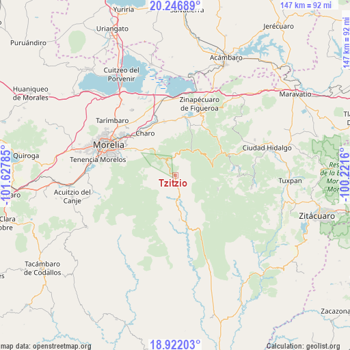
Tzitzio GPS coordinates[2]
19° 35' 8.952" North, 100° 55' 28.992" West
| Map corner | latitude | longitude |
|---|---|---|
| Upper-left | 20.24689°, | -101.62785° |
| Center: | 19.58582°, | -100.92472° |
| Lower-right: | 18.92203°, | -100.2216° |
| Map W x H: | 147.3×147.3 km | = 91.5×91.5mi |
| max Lat: | 32.7° ⇑52.2% North |
| Tzitzio: | 19.58582° |
| min Lat: | ⇓47.8% South 14.53588° |
| min Long | Tzitzio | max Long |
| -117.105° | -100.92472° | -86.73105° |
| W 27.1%⇐ | ⇒72.9% E |
Elevation
Elevation of Tzitzio is 1543 m = 5062 ft, and this is 289.3 m = 949 ft above average elevation for this country.
| Max E: |
3497 m = 11473 ft | 46.9% |
| Tzitzio | 1543 m 5062 ft | |
| Avg. | 1253.7 m = 4113 ft | |
Min E: |
-1 m = -3 ft | 53.1% |
See also: Mexico elevation on elevation.city.
Geographical zone
Tzitzio is located in North Torrid zone (between Equator and Tropic of Cancer). Distance of this Northern Tropic circle is 428.2 km =266.1 mi to North.| Distance of | km | miles | from Tzitzio |
|---|---|---|---|
| North Pole | 7829.3 | 4864.9 | to North |
| Arctic Circle | 5223.4 | 3245.7 | to North |
| Tropic Cancer | 428.2 | 266.1 | to North |
| Equator | 2177.7 | 1353.2 | to South |


Nearby cities:
15 places around Tzitzio: (largest is in red/bold)
• Charo
22.2 km =13.8 mi,  325°
325°
• El Caracol
17.8 km =11.1 mi,  95°
95°
• Francisco I. Madero (El Pantano)
16.8 km =10.4 mi,  319°
319°
• Huajúmbaro
22 km =13.7 mi,  60°
60°
• Irapeo
18.4 km =11.4 mi,  310°
310°
• Jaripeo
19.8 km =12.3 mi,  301°
301°
• Las Mesas
18.4 km =11.4 mi, 296°
• Pucuato
22.9 km =14.2 mi,  86°
86°
• Río de Parras (Otzumatlán)
21.8 km =13.5 mi,  16°
16°
• San Antonio Villalongín
18.9 km =11.7 mi,  107°
107°
• San José de las Torres
21.8 km =13.5 mi,  291°
291°
• San Miguel del Monte
22.2 km =13.8 mi,  280°
280°
• Tafetán
18.7 km =11.6 mi,  174°
174°
• Unión de Progreso (Lomas de Irapeo)
16.4 km =10.2 mi, 308°
• Zurumbeneo
15.6 km =9.7 mi, 324°
Sources, notices
• [Note1] Compared only with cities in Mexico existing in our database
• [Src1] Map data: © OpenStreetMap contributors (CC-BY-SA)
• [Src2] Other city data from geonames.org with taken over terms of usage.
• [Src3] Geographical zone / Annual Mean Temperature by Robert A. Rohde @ Wikipedia
