Guarda de Guadalupe geodata
Guarda de Guadalupe (State of Mexico) is a populated place; located in Mexico in America/Mexico_City (GMT-6) time zone. With population of 762 people, there are 11496 cities with bigger population in this country. Compared to other cities in Mexico, 51.4% of cities are located further ↓South; 64.9% of cities are located further →East and 98.7% of cities have lower elevation than Guarda de Guadalupe. Note1


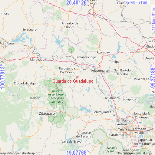
Guarda de Guadalupe GPS coordinates[2]
19° 44' 27.024" North, 100° 4' 30" West
| Map corner | latitude | longitude |
|---|---|---|
| Upper-left | 20.40126°, | -100.77813° |
| Center: | 19.74084°, | -100.075° |
| Lower-right: | 19.07768°, | -99.37188° |
| Map W x H: | 147.2×147.2 km | = 91.5×91.5mi |
| max Lat: | 32.7° ⇑48.6% North |
| Guarda de Guadalupe: | 19.74084° |
| min Lat: | ⇓51.4% South 14.53588° |
| min Long | Guarda de Guada | max Long |
| -117.105° | -100.075° | -86.73105° |
| W 35.1%⇐ | ⇒64.9% E |
Elevation
Elevation of Guarda de Guadalupe is 2812 m = 9226 ft, and this is 1558.3 m = 5113 ft above average elevation for this country.
| Max E: |
3497 m = 11473 ft | 1.3% |
| Guarda de Guadalupe | 2812 m 9226 ft | |
| Avg. | 1253.7 m = 4113 ft | |
Min E: |
-1 m = -3 ft | 98.7% |
See also: Mexico elevation on elevation.city.
Geographical zone
Guarda de Guadalupe is located in North Torrid zone (between Equator and Tropic of Cancer). Distance of this Northern Tropic circle is 410.9 km =255.3 mi to North.| Distance of | km | miles | from Guarda de Guadalupe |
|---|---|---|---|
| North Pole | 7812.1 | 4854.2 | to North |
| Arctic Circle | 5206.2 | 3235 | to North |
| Tropic Cancer | 410.9 | 255.3 | to North |
| Equator | 2195 | 1363.9 | to South |


Nearby cities:
15 places around Guarda de Guadalupe: (largest is in red/bold)
• Barrio del Gigante
3.6 km =2.2 mi,  323°
323°
• Barrio la Mesa, Rioyos Buenavista
4.4 km =2.7 mi,  155°
155°
• Cerro Llorón
5.5 km =3.4 mi,  299°
299°
• Chichilpa
4 km =2.5 mi,  121°
121°
• Dotegiare
5 km =3.1 mi,  138°
138°
• Endotejiare
6.7 km =4.2 mi,  42°
42°
• Jesús Carranza
4.9 km =3 mi,  212°
212°
• La Magdalena Morelos
5.8 km =3.6 mi,  46°
46°
• Pata de Mula de los Cedros (Patemula)
3.2 km =2 mi,  260°
260°
• Rincón de los Pirules
4.7 km =2.9 mi,  92°
92°
• San Francisco Solo
3 km =1.9 mi,  216°
216°
• San Miguel del Centro
4.2 km =2.6 mi,  237°
237°
• Santa Rita de la Cuesta
0.9 km =0.6 mi,  27°
27°
• Santa Rosa de Lima
5.5 km =3.4 mi,  336°
336°
• Santiago Oxtempan
6.6 km =4.1 mi,  311°
311°
Sources, notices
• [Note1] Compared only with cities in Mexico existing in our database
• [Src1] Map data: © OpenStreetMap contributors (CC-BY-SA)
• [Src2] Other city data from geonames.org with taken over terms of usage.
• [Src3] Geographical zone / Annual Mean Temperature by Robert A. Rohde @ Wikipedia
