Palo Amarillo geodata
Palo Amarillo (State of Mexico) is a populated place; located in Mexico in America/Mexico_City (GMT-6) time zone. With population of 583 people, there are 14713 cities with bigger population in this country. Compared to other cities in Mexico, 50.6% of cities are located further ↑North; 66.7% of cities are located further →East and 99.9% of cities have lower elevation than Palo Amarillo. Note1


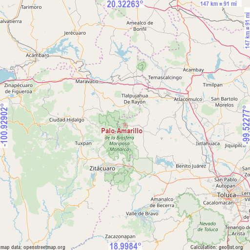
Palo Amarillo GPS coordinates[2]
19° 39' 42.768" North, 100° 13' 33.204" West
| Map corner | latitude | longitude |
|---|---|---|
| Upper-left | 20.32263°, | -100.92902° |
| Center: | 19.66188°, | -100.22589° |
| Lower-right: | 18.9984°, | -99.52277° |
| Map W x H: | 147.2×147.2 km | = 91.5×91.5mi |
| max Lat: | 32.7° ⇑50.6% North |
| Palo Amarillo: | 19.66188° |
| min Lat: | ⇓49.4% South 14.53588° |
| min Long | Palo Amarillo | max Long |
| -117.105° | -100.22589° | -86.73105° |
| W 33.3%⇐ | ⇒66.7% E |
Elevation
Elevation of Palo Amarillo is 3076 m = 10092 ft, and this is 1822.3 m = 5979 ft above average elevation for this country.
| Max E: |
3497 m = 11473 ft | 0.099999999999994% |
| Palo Amarillo | 3076 m 10092 ft | |
| Avg. | 1253.7 m = 4113 ft | |
Min E: |
-1 m = -3 ft | 99.9% |
See also: Mexico elevation on elevation.city.
Geographical zone
Palo Amarillo is located in North Torrid zone (between Equator and Tropic of Cancer). Distance of this Northern Tropic circle is 419.7 km =260.8 mi to North.| Distance of | km | miles | from Palo Amarillo |
|---|---|---|---|
| North Pole | 7820.9 | 4859.7 | to North |
| Arctic Circle | 5215 | 3240.4 | to North |
| Tropic Cancer | 419.7 | 260.8 | to North |
| Equator | 2186.2 | 1358.4 | to South |


Nearby cities:
15 places around Palo Amarillo: (largest is in red/bold)
• Concepción del Monte
7.6 km =4.7 mi,  98°
98°
• Concepción la Venta
8.4 km =5.2 mi,  67°
67°
• El Huizache
9.7 km =6 mi,  142°
142°
• Fábrica Concepción
9.9 km =6.2 mi,  107°
107°
• Fábrica Pueblo Nuevo
8.3 km =5.2 mi,  76°
76°
• La Esperanza
8.8 km =5.5 mi,  124°
124°
• La Salud
9.4 km =5.8 mi,  219°
219°
• Manzana Rancho Escondido
9.8 km =6.1 mi,  211°
211°
• Mineral de Angangueo
7.7 km =4.8 mi,  233°
233°
• Rincón de Lijadero
9.8 km =6.1 mi,  152°
152°
• San Felipe de Jesús
4.3 km =2.7 mi, 140°
• San José Corrales
7.6 km =4.7 mi,  334°
334°
• San José del Rincón Centro
7.6 km =4.7 mi,  89°
89°
• San Rafael
7.6 km =4.7 mi,  2°
2°
• Santa Cruz del Tejocote
6.4 km =4 mi, 71°
Sources, notices
• [Note1] Compared only with cities in Mexico existing in our database
• [Src1] Map data: © OpenStreetMap contributors (CC-BY-SA)
• [Src2] Other city data from geonames.org with taken over terms of usage.
• [Src3] Geographical zone / Annual Mean Temperature by Robert A. Rohde @ Wikipedia
