San Rafael geodata
San Rafael (Michoacán) is a populated place; located in Mexico in America/Mexico_City (GMT-6) time zone. With population of 548 people, there are 15532 cities with bigger population in this country. Compared to other cities in Mexico, 51.1% of cities are located further ↓South; 66.7% of cities are located further →East and 97% of cities have lower elevation than San Rafael. Note1


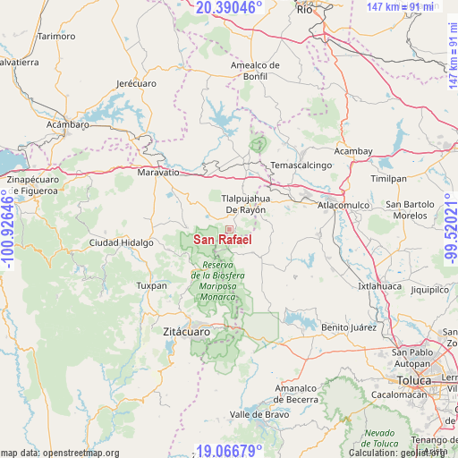
San Rafael GPS coordinates[2]
19° 43' 48" North, 100° 13' 23.988" West
| Map corner | latitude | longitude |
|---|---|---|
| Upper-left | 20.39046°, | -100.92646° |
| Center: | 19.73°, | -100.22333° |
| Lower-right: | 19.06679°, | -99.52021° |
| Map W x H: | 147.2×147.2 km | = 91.5×91.5mi |
| max Lat: | 32.7° ⇑48.9% North |
| San Rafael: | 19.73° |
| min Lat: | ⇓51.1% South 14.53588° |
| min Long | San Rafael | max Long |
| -117.105° | -100.22333° | -86.73105° |
| W 33.3%⇐ | ⇒66.7% E |
Elevation
Elevation of San Rafael is 2676 m = 8780 ft, and this is 1422.3 m = 4666 ft above average elevation for this country.
| Max E: |
3497 m = 11473 ft | 3% |
| San Rafael | 2676 m 8780 ft | |
| Avg. | 1253.7 m = 4113 ft | |
Min E: |
-1 m = -3 ft | 97% |
See also: Mexico elevation on elevation.city.
Geographical zone
San Rafael is located in North Torrid zone (between Equator and Tropic of Cancer). Distance of this Northern Tropic circle is 412.1 km =256.1 mi to North.| Distance of | km | miles | from San Rafael |
|---|---|---|---|
| North Pole | 7813.3 | 4855 | to North |
| Arctic Circle | 5207.4 | 3235.7 | to North |
| Tropic Cancer | 412.1 | 256.1 | to North |
| Equator | 2193.8 | 1363.2 | to South |


Nearby cities:
15 places around San Rafael: (largest is in red/bold)
• Chincua (Colonia Emiliano Zapata)
7.7 km =4.8 mi,  295°
295°
• Concepción la Venta
8.6 km =5.3 mi,  119°
119°
• Estanzuela (La Hacienda)
6.5 km =4 mi,  41°
41°
• Guadalupe Victoria
6.6 km =4.1 mi,  323°
323°
• La Mesa
9.1 km =5.7 mi,  57°
57°
• Los Remedios
8.4 km =5.2 mi,  20°
20°
• Los Reyes
4.7 km =2.9 mi,  310°
310°
• Monte Alegre
8.1 km =5 mi,  9°
9°
• Palo Amarillo
7.6 km =4.7 mi,  182°
182°
• San Isidro
4.7 km =2.9 mi,  25°
25°
• San José Corrales
3.6 km =2.2 mi,  259°
259°
• San Juan Tlalpujahuilla (Tlalpujahuilla)
9.1 km =5.7 mi, 42°
• San Pedro Tarímbaro
8.7 km =5.4 mi,  358°
358°
• Santa Cruz del Tejocote
8 km =5 mi,  133°
133°
• Santa María de los Ángeles
6.7 km =4.2 mi, 21°
Sources, notices
• [Note1] Compared only with cities in Mexico existing in our database
• [Src1] Map data: © OpenStreetMap contributors (CC-BY-SA)
• [Src2] Other city data from geonames.org with taken over terms of usage.
• [Src3] Geographical zone / Annual Mean Temperature by Robert A. Rohde @ Wikipedia
