Tres Estrellas geodata
Tres Estrellas (State of Mexico) is a populated place; located in Mexico in America/Mexico_City (GMT-6) time zone. With population of 1,467 people, there are 5888 cities with bigger population in this country. Compared to other cities in Mexico, 52.2% of cities are located further ↑North; 64.3% of cities are located further →East and 98.8% of cities have lower elevation than Tres Estrellas. Note1


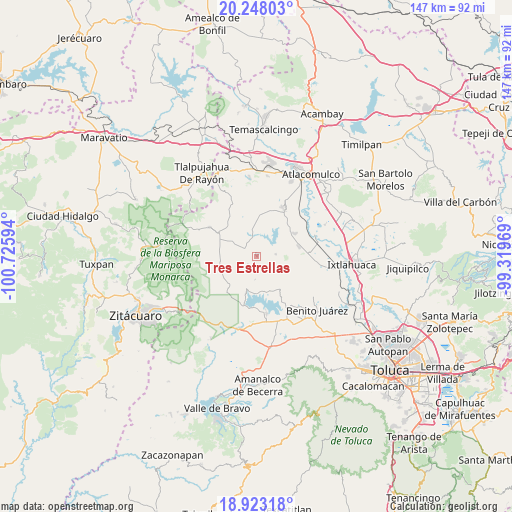
Tres Estrellas GPS coordinates[2]
19° 35' 13.092" North, 100° 1' 22.116" West
| Map corner | latitude | longitude |
|---|---|---|
| Upper-left | 20.24803°, | -100.72594° |
| Center: | 19.58697°, | -100.02281° |
| Lower-right: | 18.92318°, | -99.31969° |
| Map W x H: | 147.3×147.3 km | = 91.5×91.5mi |
| max Lat: | 32.7° ⇑52.2% North |
| Tres Estrellas: | 19.58697° |
| min Lat: | ⇓47.8% South 14.53588° |
| min Long | Tres Estrellas | max Long |
| -117.105° | -100.02281° | -86.73105° |
| W 35.7%⇐ | ⇒64.3% E |
Elevation
Elevation of Tres Estrellas is 2824 m = 9265 ft, and this is 1570.3 m = 5152 ft above average elevation for this country.
| Max E: |
3497 m = 11473 ft | 1.2% |
| Tres Estrellas | 2824 m 9265 ft | |
| Avg. | 1253.7 m = 4113 ft | |
Min E: |
-1 m = -3 ft | 98.8% |
See also: Mexico elevation on elevation.city.
Geographical zone
Tres Estrellas is located in North Torrid zone (between Equator and Tropic of Cancer). Distance of this Northern Tropic circle is 428.1 km =266 mi to North.| Distance of | km | miles | from Tres Estrellas |
|---|---|---|---|
| North Pole | 7829.2 | 4864.8 | to North |
| Arctic Circle | 5223.3 | 3245.6 | to North |
| Tropic Cancer | 428.1 | 266 | to North |
| Equator | 2177.9 | 1353.3 | to South |


Nearby cities:
15 places around Tres Estrellas: (largest is in red/bold)
• Agua Grande
6.1 km =3.8 mi,  179°
179°
• Agua Zarca
4.5 km =2.8 mi, 176°
• Barrio de Puentecillas
7 km =4.3 mi,  145°
145°
• Barrio las Palomas, Santa Ana Nichi
2.2 km =1.4 mi,  96°
96°
• Calvario del Carmen
5.6 km =3.5 mi,  13°
13°
• Dios Padre
5.4 km =3.4 mi,  304°
304°
• Ejido la Virgen
3.4 km =2.1 mi,  289°
289°
• Guadalupe Coté
4.8 km =3 mi,  56°
56°
• Loma del Rancho
5.8 km =3.6 mi,  283°
283°
• Ramejé
6.8 km =4.2 mi,  172°
172°
• Ranchería la Ciénega
6.7 km =4.2 mi,  333°
333°
• San Antonio de las Huertas
6.1 km =3.8 mi,  116°
116°
• San Juan Cote Ejido
7 km =4.3 mi,  73°
73°
• San Nicolás Guadalupe
3.1 km =1.9 mi,  344°
344°
• Santa Ana Nichi Ejido
3.5 km =2.2 mi,  94°
94°
Sources, notices
• [Note1] Compared only with cities in Mexico existing in our database
• [Src1] Map data: © OpenStreetMap contributors (CC-BY-SA)
• [Src2] Other city data from geonames.org with taken over terms of usage.
• [Src3] Geographical zone / Annual Mean Temperature by Robert A. Rohde @ Wikipedia
