Loma del Rancho geodata
Loma del Rancho (State of Mexico) is a populated place; located in Mexico in America/Mexico_City (GMT-6) time zone. With population of 567 people, there are 15067 cities with bigger population in this country. Compared to other cities in Mexico, 51.9% of cities are located further ↑North; 64.9% of cities are located further →East and 97% of cities have lower elevation than Loma del Rancho. Note1


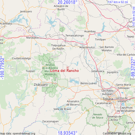
Loma del Rancho GPS coordinates[2]
19° 35' 57.012" North, 100° 4' 35.004" West
| Map corner | latitude | longitude |
|---|---|---|
| Upper-left | 20.26018°, | -100.77952° |
| Center: | 19.59917°, | -100.07639° |
| Lower-right: | 18.93543°, | -99.37327° |
| Map W x H: | 147.3×147.3 km | = 91.5×91.5mi |
| max Lat: | 32.7° ⇑51.9% North |
| Loma del Rancho: | 19.59917° |
| min Lat: | ⇓48.1% South 14.53588° |
| min Long | Loma del Rancho | max Long |
| -117.105° | -100.07639° | -86.73105° |
| W 35.1%⇐ | ⇒64.9% E |
Elevation
Elevation of Loma del Rancho is 2678 m = 8786 ft, and this is 1424.3 m = 4673 ft above average elevation for this country.
| Max E: |
3497 m = 11473 ft | 3% |
| Loma del Rancho | 2678 m 8786 ft | |
| Avg. | 1253.7 m = 4113 ft | |
Min E: |
-1 m = -3 ft | 97% |
See also: Mexico elevation on elevation.city.
Geographical zone
Loma del Rancho is located in North Torrid zone (between Equator and Tropic of Cancer). Distance of this Northern Tropic circle is 426.7 km =265.1 mi to North.| Distance of | km | miles | from Loma del Rancho |
|---|---|---|---|
| North Pole | 7827.8 | 4864 | to North |
| Arctic Circle | 5222 | 3244.8 | to North |
| Tropic Cancer | 426.7 | 265.1 | to North |
| Equator | 2179.2 | 1354.1 | to South |


Nearby cities:
15 places around Loma del Rancho: (largest is in red/bold)
• Barrio Santa Juanita el Depósito
7.9 km =4.9 mi,  220°
220°
• Barrio las Palomas, Santa Ana Nichi
7.9 km =4.9 mi,  101°
101°
• Dios Padre
2.1 km =1.3 mi,  34°
34°
• Ejido la Soledad
6 km =3.7 mi,  328°
328°
• Ejido la Virgen
2.5 km =1.6 mi, 96°
• El Puente
7.7 km =4.8 mi,  225°
225°
• El Valerio
6.3 km =3.9 mi,  337°
337°
• Fábrica Concepción
7.4 km =4.6 mi,  302°
302°
• Guadalupe Buenavista
5.5 km =3.4 mi,  284°
284°
• Guadalupe Chico
6 km =3.7 mi,  268°
268°
• Los Lobos Segunda Sección
6.3 km =3.9 mi, 220°
• Ranchería la Ciénega
5.3 km =3.3 mi, 29°
• San Miguel Agua Bendita
3.5 km =2.2 mi,  354°
354°
• San Nicolás Guadalupe
5.1 km =3.2 mi,  70°
70°
• Tres Estrellas
5.8 km =3.6 mi, 103°
Sources, notices
• [Note1] Compared only with cities in Mexico existing in our database
• [Src1] Map data: © OpenStreetMap contributors (CC-BY-SA)
• [Src2] Other city data from geonames.org with taken over terms of usage.
• [Src3] Geographical zone / Annual Mean Temperature by Robert A. Rohde @ Wikipedia
