Barrio de Puentecillas geodata
Barrio de Puentecillas (State of Mexico) is a populated place; located in Mexico in America/Mexico_City (GMT-6) time zone. With population of 1,027 people, there are 8485 cities with bigger population in this country. Compared to other cities in Mexico, 53.4% of cities are located further ↑North; 63.8% of cities are located further →East and 98.2% of cities have lower elevation than Barrio de Puentecillas. Note1


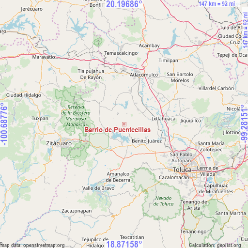
Barrio de Puentecillas GPS coordinates[2]
19° 32' 8.088" North, 99° 59' 4.668" West
| Map corner | latitude | longitude |
|---|---|---|
| Upper-left | 20.19686°, | -100.68776° |
| Center: | 19.53558°, | -99.98463° |
| Lower-right: | 18.87158°, | -99.28151° |
| Map W x H: | 147.4×147.4 km | = 91.6×91.6mi |
| max Lat: | 32.7° ⇑53.4% North |
| Barrio de Puentecillas: | 19.53558° |
| min Lat: | ⇓46.6% South 14.53588° |
| min Long | Barrio de Puent | max Long |
| -117.105° | -99.98463° | -86.73105° |
| W 36.2%⇐ | ⇒63.8% E |
Elevation
Elevation of Barrio de Puentecillas is 2766 m = 9075 ft, and this is 1512.3 m = 4962 ft above average elevation for this country.
| Max E: |
3497 m = 11473 ft | 1.8% |
| Barrio de Puentecillas | 2766 m 9075 ft | |
| Avg. | 1253.7 m = 4113 ft | |
Min E: |
-1 m = -3 ft | 98.2% |
See also: Mexico elevation on elevation.city.
Geographical zone
Barrio de Puentecillas is located in North Torrid zone (between Equator and Tropic of Cancer). Distance of this Northern Tropic circle is 433.8 km =269.6 mi to North.| Distance of | km | miles | from Barrio de Puentecillas |
|---|---|---|---|
| North Pole | 7834.9 | 4868.4 | to North |
| Arctic Circle | 5229 | 3249.1 | to North |
| Tropic Cancer | 433.8 | 269.6 | to North |
| Equator | 2172.2 | 1349.7 | to South |


Nearby cities:
15 places around Barrio de Puentecillas: (largest is in red/bold)
• Agua Grande
3.9 km =2.4 mi,  264°
264°
• Agua Zarca
4 km =2.5 mi,  288°
288°
• Barrio de Centro del Cerrillo
3.2 km =2 mi,  87°
87°
• Barrio de San Isidro
3.2 km =2 mi,  120°
120°
• Barrio de San Miguel
4.1 km =2.5 mi,  129°
129°
• Barrio el Centenario
2.2 km =1.4 mi,  210°
210°
• Cuadrilla Vieja
2.6 km =1.6 mi,  185°
185°
• Fresno Nichi
5.1 km =3.2 mi,  47°
47°
• La Alameda
2.9 km =1.8 mi,  165°
165°
• Loma de Guadalupe
3.4 km =2.1 mi, 210°
• Mina Vieja
4.7 km =2.9 mi,  66°
66°
• Ramejé
3.2 km =2 mi,  251°
251°
• San Antonio de las Huertas
3.3 km =2.1 mi,  25°
25°
• San Diego del Cerrito
3.9 km =2.4 mi,  217°
217°
• San Marcos de la Loma
4.6 km =2.9 mi,  146°
146°
Sources, notices
• [Note1] Compared only with cities in Mexico existing in our database
• [Src1] Map data: © OpenStreetMap contributors (CC-BY-SA)
• [Src2] Other city data from geonames.org with taken over terms of usage.
• [Src3] Geographical zone / Annual Mean Temperature by Robert A. Rohde @ Wikipedia
