Cuauhlotitlán geodata
Cuauhlotitlán (Guerrero) is a populated place; located in Mexico in America/Mexico_City (GMT-6) time zone. With population of 863 people, there are 10137 cities with bigger population in this country. Compared to other cities in Mexico, 74.3% of cities are located further ↑North; 67.7% of cities are located further →East and 71.6% of cities have higher elevation than Cuauhlotitlán. Note1


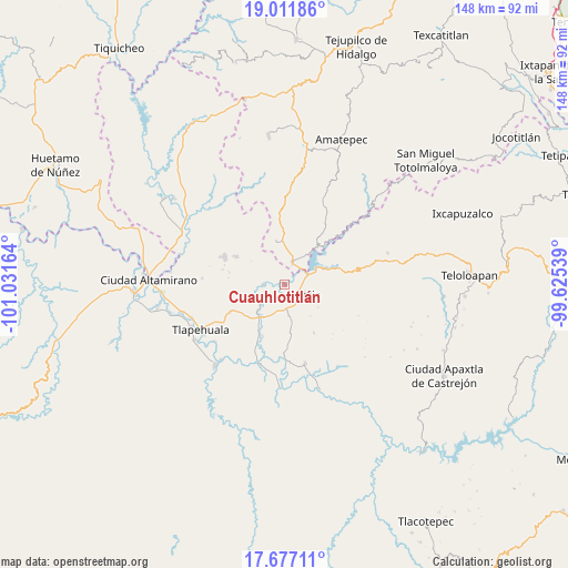
Cuauhlotitlán GPS coordinates[2]
18° 20' 44.772" North, 100° 19' 42.636" West
| Map corner | latitude | longitude |
|---|---|---|
| Upper-left | 19.01186°, | -101.03164° |
| Center: | 18.34577°, | -100.32851° |
| Lower-right: | 17.67711°, | -99.62539° |
| Map W x H: | 148.4×148.4 km | = 92.2×92.2mi |
| max Lat: | 32.7° ⇑74.3% North |
| Cuauhlotitlán: | 18.34577° |
| min Lat: | ⇓25.7% South 14.53588° |
| min Long | Cuauhlotitlán | max Long |
| -117.105° | -100.32851° | -86.73105° |
| W 32.3%⇐ | ⇒67.7% E |
Elevation
Elevation of Cuauhlotitlán is 345 m = 1132 ft, and this is 908.7 m = 2981 ft below average elevation for this country.
| Max E: |
3497 m = 11473 ft | 71.6% |
| Avg. | 1253.7 m = 4113 ft | |
| Cuauhlotitlán | 345 m = 1132 ft | |
Min E: |
-1 m = -3 ft | 28.4% |
See also: Mexico elevation on elevation.city.
Geographical zone
Cuauhlotitlán is located in North Torrid zone (between Equator and Tropic of Cancer). Distance of this Northern Tropic circle is 566.1 km =351.8 mi to North.| Distance of | km | miles | from Cuauhlotitlán |
|---|---|---|---|
| North Pole | 7967.2 | 4950.6 | to North |
| Arctic Circle | 5361.3 | 3331.4 | to North |
| Tropic Cancer | 566.1 | 351.8 | to North |
| Equator | 2039.9 | 1267.5 | to South |


Nearby cities:
15 places around Cuauhlotitlán: (largest is in red/bold)
• Arcelia
5.8 km =3.6 mi,  121°
121°
• Colonia Emperador Cuauhtémoc
6.8 km =4.2 mi,  147°
147°
• El Escondido
14 km =8.7 mi,  172°
172°
• El Naranjo
5.7 km =3.5 mi,  45°
45°
• El Temblor
5.5 km =3.4 mi,  21°
21°
• Nuevo Copaltepec
6.1 km =3.8 mi,  44°
44°
• Palos Altos
6.4 km =4 mi,  64°
64°
• Reforma de Lázaro Cárdenas (El Aterrizaje)
7.4 km =4.6 mi,  142°
142°
• Rincón Grande
11.5 km =7.1 mi,  349°
349°
• San Antonio del Rosario
6.4 km =4 mi, 19°
• San Bartolo
14.9 km =9.3 mi,  202°
202°
• San José Poliutla
10.4 km =6.5 mi,  219°
219°
• San Miguel Tecomatlán
8.4 km =5.2 mi,  248°
248°
• Santo Niño
6.6 km =4.1 mi,  175°
175°
• Villa Madero
14.6 km =9.1 mi,  299°
299°
Sources, notices
• [Note1] Compared only with cities in Mexico existing in our database
• [Src1] Map data: © OpenStreetMap contributors (CC-BY-SA)
• [Src2] Other city data from geonames.org with taken over terms of usage.
• [Src3] Geographical zone / Annual Mean Temperature by Robert A. Rohde @ Wikipedia
