Nuevo Copaltepec geodata
Nuevo Copaltepec (State of Mexico) is a populated place; located in Mexico in America/Mexico_City (GMT-6) time zone. With population of 655 people, there are 13244 cities with bigger population in this country. Compared to other cities in Mexico, 74% of cities are located further ↑North; 67.2% of cities are located further →East and 70.9% of cities have higher elevation than Nuevo Copaltepec. Note1


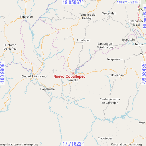
Nuevo Copaltepec GPS coordinates[2]
18° 23' 5.064" North, 100° 17' 14.892" West
| Map corner | latitude | longitude |
|---|---|---|
| Upper-left | 19.05067°, | -100.9906° |
| Center: | 18.38474°, | -100.28747° |
| Lower-right: | 17.71622°, | -99.58435° |
| Map W x H: | 148.4×148.4 km | = 92.2×92.2mi |
| max Lat: | 32.7° ⇑74% North |
| Nuevo Copaltepec: | 18.38474° |
| min Lat: | ⇓26% South 14.53588° |
| min Long | Nuevo Copaltepe | max Long |
| -117.105° | -100.28747° | -86.73105° |
| W 32.8%⇐ | ⇒67.2% E |
Elevation
Elevation of Nuevo Copaltepec is 373 m = 1224 ft, and this is 880.7 m = 2889 ft below average elevation for this country.
| Max E: |
3497 m = 11473 ft | 70.9% |
| Avg. | 1253.7 m = 4113 ft | |
| Nuevo Copaltepec | 373 m = 1224 ft | |
Min E: |
-1 m = -3 ft | 29.1% |
See also: Mexico elevation on elevation.city.
Geographical zone
Nuevo Copaltepec is located in North Torrid zone (between Equator and Tropic of Cancer). Distance of this Northern Tropic circle is 561.7 km =349 mi to North.| Distance of | km | miles | from Nuevo Copaltepec |
|---|---|---|---|
| North Pole | 7962.9 | 4947.9 | to North |
| Arctic Circle | 5357 | 3328.7 | to North |
| Tropic Cancer | 561.7 | 349 | to North |
| Equator | 2044.2 | 1270.2 | to South |


Nearby cities:
15 places around Nuevo Copaltepec: (largest is in red/bold)
• Almoloya
11.9 km =7.4 mi,  98°
98°
• Arcelia
7.4 km =4.6 mi,  175°
175°
• Colonia Emperador Cuauhtémoc
10.1 km =6.3 mi, 183°
• Cuauhlotitlán
6.1 km =3.8 mi,  224°
224°
• El Escondido
18.4 km =11.4 mi,  188°
188°
• El Naranjo
0.4 km =0.2 mi, 219°
• El Temblor
2.5 km =1.6 mi,  288°
288°
• Palos Altos
2.1 km =1.3 mi,  138°
138°
• Reforma de Lázaro Cárdenas (El Aterrizaje)
10.2 km =6.3 mi, 179°
• Rincón Grande
9.5 km =5.9 mi,  317°
317°
• San Antonio del Rosario
2.8 km =1.7 mi,  307°
307°
• San José Poliutla
16.5 km =10.3 mi, 221°
• San Miguel Tecomatlán
14.2 km =8.8 mi,  238°
238°
• Santo Niño
11.6 km =7.2 mi,  199°
199°
• Villa Madero
17.2 km =10.7 mi,  279°
279°
Sources, notices
• [Note1] Compared only with cities in Mexico existing in our database
• [Src1] Map data: © OpenStreetMap contributors (CC-BY-SA)
• [Src2] Other city data from geonames.org with taken over terms of usage.
• [Src3] Geographical zone / Annual Mean Temperature by Robert A. Rohde @ Wikipedia
