Ajuchitlán del Progreso geodata
Ajuchitlán del Progreso (Guerrero) is a populated place; located in Mexico in America/Mexico_City (GMT-6) time zone. With population of 6,329 people, there are 1468 cities with bigger population in this country. Compared to other cities in Mexico, 76.8% of cities are located further ↑North; 69.4% of cities are located further →East and 72.8% of cities have higher elevation than Ajuchitlán del Progreso. Note1
Current local time in Ajuchitlán del Progreso:
04:06 AM, FridayDifference from your time zone: hours


Ajuchitlán del Progreso GPS coordinates[2]
18° 9' 6.804" North, 100° 29' 0.708" West
| Map corner | latitude | longitude |
|---|---|---|
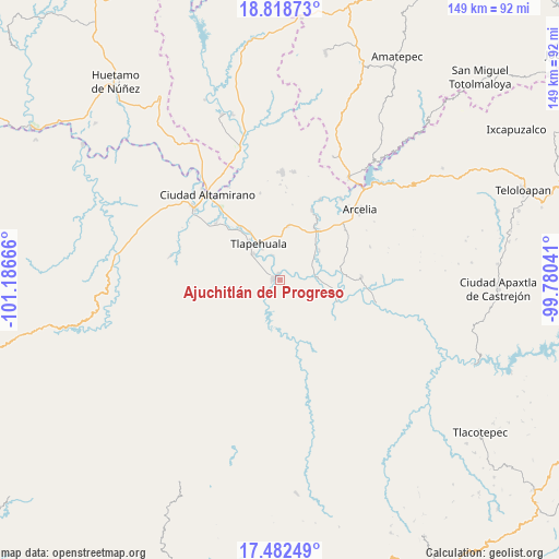
| Upper-left | 18.81873°, | -101.18666° |
| Center: | 18.15189°, | -100.48353° |
| Lower-right: | 17.48249°, | -99.78041° |
| Map W x H: | 148.6×148.6 km | = 92.3×92.3mi |
| max Lat: | 32.7° ⇑76.8% North |
| Ajuchitlán del Progreso: | 18.15189° |
| min Lat: | ⇓23.2% South 14.53588° |
| min Long | Ajuchitlán del | max Long |
| -117.105° | -100.48353° | -86.73105° |
| W 30.6%⇐ | ⇒69.4% E |
Elevation
Elevation of Ajuchitlán del Progreso is 297 m = 974 ft, and this is 956.7 m = 3139 ft below average elevation for this country.
| Max E: |
3497 m = 11473 ft | 72.8% |
| Avg. | 1253.7 m = 4113 ft | |
| Ajuchitlán del Progreso | 297 m = 974 ft | |
Min E: |
-1 m = -3 ft | 27.2% |
See also: Mexico elevation on elevation.city.
Geographical zone
Ajuchitlán del Progreso is located in North Torrid zone (between Equator and Tropic of Cancer). Distance of this Northern Tropic circle is 587.6 km =365.1 mi to North.| Distance of | km | miles | from Ajuchitlán del Progreso |
|---|---|---|---|
| North Pole | 7988.8 | 4964 | to North |
| Arctic Circle | 5382.9 | 3344.8 | to North |
| Tropic Cancer | 587.6 | 365.1 | to North |
| Equator | 2018.3 | 1254.1 | to South |


Nearby cities:
15 places around Ajuchitlán del Progreso: (largest is in red/bold)
• Ayavitle
5.8 km =3.6 mi,  339°
339°
• Cantón de Guerrero
10.7 km =6.6 mi,  324°
324°
• El Reparo
4.1 km =2.5 mi,  214°
214°
• La Laja
5.8 km =3.6 mi,  178°
178°
• Las Anonitas
11.5 km =7.1 mi,  301°
301°
• Nuevo Guerrero
9.4 km =5.8 mi,  331°
331°
• San Antonio de la Gavia
11.7 km =7.3 mi,  111°
111°
• San Cristóbal
2.1 km =1.3 mi,  350°
350°
• San Jerónimo el Grande
6.9 km =4.3 mi, 343°
• San Mateo
6.1 km =3.8 mi, 326°
• San Miguel Totolapan
9.9 km =6.2 mi,  83°
83°
• San Pedro y las Garzas
7.9 km =4.9 mi, 206°
• Santa Rosa de Lima Dos
7 km =4.3 mi,  280°
280°
• Tlapehuala
11.5 km =7.1 mi, 329°
• Villa Nicolás Bravo
9.7 km =6 mi, 315°
Sources, notices
• [Note1] Compared only with cities in Mexico existing in our database
• [Src1] Map data: © OpenStreetMap contributors (CC-BY-SA)
• [Src2] Other city data from geonames.org with taken over terms of usage.
• [Src3] Geographical zone / Annual Mean Temperature by Robert A. Rohde @ Wikipedia
