Pericotepec geodata
Pericotepec (Guerrero) is a populated place; located in Mexico in America/Mexico_City (GMT-6) time zone. With population of 515 people, there are 16340 cities with bigger population in this country. Compared to other cities in Mexico, 79.2% of cities are located further ↑North; 66.6% of cities are located further →East and 52.5% of cities have lower elevation than Pericotepec. Note1


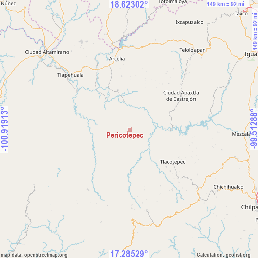
Pericotepec GPS coordinates[2]
17° 57' 19.512" North, 100° 12' 57.6" West
| Map corner | latitude | longitude |
|---|---|---|
| Upper-left | 18.62302°, | -100.91913° |
| Center: | 17.95542°, | -100.216° |
| Lower-right: | 17.28529°, | -99.51288° |
| Map W x H: | 148.7×148.7 km | = 92.4×92.4mi |
| max Lat: | 32.7° ⇑79.2% North |
| Pericotepec: | 17.95542° |
| min Lat: | ⇓20.8% South 14.53588° |
| min Long | Pericotepec | max Long |
| -117.105° | -100.216° | -86.73105° |
| W 33.4%⇐ | ⇒66.6% E |
Elevation
Elevation of Pericotepec is 1533 m = 5030 ft, and this is 279.3 m = 916 ft above average elevation for this country.
| Max E: |
3497 m = 11473 ft | 47.5% |
| Pericotepec | 1533 m 5030 ft | |
| Avg. | 1253.7 m = 4113 ft | |
Min E: |
-1 m = -3 ft | 52.5% |
See also: Mexico elevation on elevation.city.
Geographical zone
Pericotepec is located in North Torrid zone (between Equator and Tropic of Cancer). Distance of this Northern Tropic circle is 609.5 km =378.7 mi to North.| Distance of | km | miles | from Pericotepec |
|---|---|---|---|
| North Pole | 8010.6 | 4977.6 | to North |
| Arctic Circle | 5404.7 | 3358.3 | to North |
| Tropic Cancer | 609.5 | 378.7 | to North |
| Equator | 1996.5 | 1240.6 | to South |


Nearby cities:
15 places around Pericotepec: (largest is in red/bold)
• Chichiltepec
22.9 km =14.2 mi,  135°
135°
• Durazno del Rosario
24.2 km =15 mi,  156°
156°
• El Aguaje
30.7 km =19.1 mi,  330°
330°
• El Guayabo
23.6 km =14.7 mi,  343°
343°
• El Remance
27.7 km =17.2 mi, 333°
• El Terrero
22.2 km =13.8 mi, 330°
• Huautla
16.5 km =10.3 mi,  133°
133°
• Las Juntas
30.7 km =19.1 mi, 326°
• Nuevo Poblado el Caracol
20.5 km =12.7 mi,  89°
89°
• San Antonio de la Gavia
24.7 km =15.3 mi,  315°
315°
• San Miguel Totolapan
29.4 km =18.3 mi, 321°
• Valle Galeana (El Tamarindo)
19.6 km =12.2 mi,  352°
352°
• Valle Luz
23.5 km =14.6 mi, 326°
• Villa Hidalgo (El Cubo)
25.2 km =15.7 mi, 335°
• Zompantle
30.4 km =18.9 mi, 135°
Sources, notices
• [Note1] Compared only with cities in Mexico existing in our database
• [Src1] Map data: © OpenStreetMap contributors (CC-BY-SA)
• [Src2] Other city data from geonames.org with taken over terms of usage.
• [Src3] Geographical zone / Annual Mean Temperature by Robert A. Rohde @ Wikipedia
