Maya Tecún I geodata
Maya Tecún I (Campeche) is a populated place; located in Mexico in America/Merida (GMT-6) time zone. With population of 1,254 people, there are 6906 cities with bigger population in this country. Compared to other cities in Mexico, 62.1% of cities are located further ↑North; 97.2% of cities are located further ←West and 82% of cities have higher elevation than Maya Tecún I. Note1


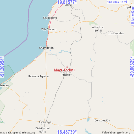
Maya Tecún I GPS coordinates[2]
19° 9' 10.512" North, 90° 30' 23.076" West
| Map corner | latitude | longitude |
|---|---|---|
| Upper-left | 19.81577°, | -91.20954° |
| Center: | 19.15292°, | -90.50641° |
| Lower-right: | 18.48739°, | -89.80329° |
| Map W x H: | 147.7×147.7 km | = 91.8×91.8mi |
| max Lat: | 32.7° ⇑62.1% North |
| Maya Tecún I: | 19.15292° |
| min Lat: | ⇓37.9% South 14.53588° |
| min Long | Maya Tecún I | max Long |
| -117.105° | -90.50641° | -86.73105° |
| W 97.2%⇐ | ⇒2.8% E |
Elevation
Elevation of Maya Tecún I is 70 m = 230 ft, and this is 1183.7 m = 3884 ft below average elevation for this country.
| Max E: |
3497 m = 11473 ft | 82% |
| Avg. | 1253.7 m = 4113 ft | |
| Maya Tecún I | 70 m = 230 ft | |
Min E: |
-1 m = -3 ft | 18% |
See also: Mexico elevation on elevation.city.
Geographical zone
Maya Tecún I is located in North Torrid zone (between Equator and Tropic of Cancer). Distance of this Northern Tropic circle is 476.3 km =296 mi to North.| Distance of | km | miles | from Maya Tecún I |
|---|---|---|---|
| North Pole | 7877.5 | 4894.9 | to North |
| Arctic Circle | 5271.6 | 3275.6 | to North |
| Tropic Cancer | 476.3 | 296 | to North |
| Equator | 2129.6 | 1323.3 | to South |


Nearby cities:
15 places around Maya Tecún I: (largest is in red/bold)
• Aquiles Serdán (Chuiná)
30.3 km =18.8 mi,  226°
226°
• Carrillo Puerto
6.8 km =4.2 mi,  194°
194°
• Champotón
31.2 km =19.4 mi,  313°
313°
• Cinco de Febrero
35.6 km =22.1 mi,  202°
202°
• General Ortiz Ávila
30.9 km =19.2 mi, 228°
• José María Morelos y Pavón
23.6 km =14.7 mi,  253°
253°
• Kikab
34.7 km =21.6 mi,  64°
64°
• Maya Tecún II
1.3 km =0.8 mi,  2°
2°
• Moquel
28.3 km =17.6 mi,  321°
321°
• Pixoyal
26.2 km =16.3 mi, 201°
• Pustunich
3 km =1.9 mi,  110°
110°
• San Pablo Pixtún
23.8 km =14.8 mi,  264°
264°
• Ulumal
18.1 km =11.2 mi, 317°
• Xbacab
32.7 km =20.3 mi,  223°
223°
• Yohaltún
25.5 km =15.8 mi,  127°
127°
Sources, notices
• [Note1] Compared only with cities in Mexico existing in our database
• [Src1] Map data: © OpenStreetMap contributors (CC-BY-SA)
• [Src2] Other city data from geonames.org with taken over terms of usage.
• [Src3] Geographical zone / Annual Mean Temperature by Robert A. Rohde @ Wikipedia
