Antonio M. Quirazco geodata
Antonio M. Quirazco (Puebla) is a populated place; located in Mexico in America/Mexico_City (GMT-6) time zone. With population of 669 people, there are 12968 cities with bigger population in this country. Compared to other cities in Mexico, 69.2% of cities are located further ↓South; 68.4% of cities are located further ←West and 79.8% of cities have higher elevation than Antonio M. Quirazco. Note1


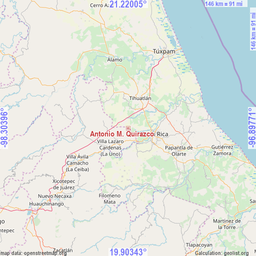
Antonio M. Quirazco GPS coordinates[2]
20° 33' 47.376" North, 97° 36' 2.988" West
| Map corner | latitude | longitude |
|---|---|---|
| Upper-left | 21.22005°, | -98.30396° |
| Center: | 20.56316°, | -97.60083° |
| Lower-right: | 19.90343°, | -96.89771° |
| Map W x H: | 146.4×146.4 km | = 91×91mi |
| max Lat: | 32.7° ⇑30.8% North |
| Antonio M. Quirazco: | 20.56316° |
| min Lat: | ⇓69.2% South 14.53588° |
| min Long | Antonio M. Quir | max Long |
| -117.105° | -97.60083° | -86.73105° |
| W 68.4%⇐ | ⇒31.6% E |
Elevation
Elevation of Antonio M. Quirazco is 97 m = 318 ft, and this is 1156.7 m = 3795 ft below average elevation for this country.
| Max E: |
3497 m = 11473 ft | 79.8% |
| Avg. | 1253.7 m = 4113 ft | |
| Antonio M. Quirazco | 97 m = 318 ft | |
Min E: |
-1 m = -3 ft | 20.2% |
See also: Mexico elevation on elevation.city.
Geographical zone
Antonio M. Quirazco is located in North Torrid zone (between Equator and Tropic of Cancer). Distance of this Northern Tropic circle is 319.5 km =198.5 mi to North.| Distance of | km | miles | from Antonio M. Quirazco |
|---|---|---|---|
| North Pole | 7720.7 | 4797.4 | to North |
| Arctic Circle | 5114.8 | 3178.2 | to North |
| Tropic Cancer | 319.5 | 198.5 | to North |
| Equator | 2286.4 | 1420.7 | to South |


Nearby cities:
15 places around Antonio M. Quirazco: (largest is in red/bold)
• Corralillos
11.9 km =7.4 mi,  138°
138°
• El Copal
7.1 km =4.4 mi,  30°
30°
• Emiliano Zapata
8 km =5 mi,  101°
101°
• Enrique Rodríguez Cano (Zapotalillo)
12 km =7.5 mi, 26°
• Huizotate
8 km =5 mi,  70°
70°
• La Isla (Kilómetro 10)
11.5 km =7.1 mi,  64°
64°
• La Isla Km 10
11.6 km =7.2 mi, 65°
• Miguel Hidalgo
10.3 km =6.4 mi, 96°
• Nuevo Progreso
11.5 km =7.1 mi, 57°
• Poza Azul de los Reyes
10.9 km =6.8 mi,  305°
305°
• San José
10.5 km =6.5 mi,  270°
270°
• Santa María
10.6 km =6.6 mi,  156°
156°
• Venustiano Carranza
9.4 km =5.8 mi,  228°
228°
• Vizcaíno
9.4 km =5.8 mi, 158°
• Zacate Colorado
10.8 km =6.7 mi,  132°
132°
Sources, notices
• [Note1] Compared only with cities in Mexico existing in our database
• [Src1] Map data: © OpenStreetMap contributors (CC-BY-SA)
• [Src2] Other city data from geonames.org with taken over terms of usage.
• [Src3] Geographical zone / Annual Mean Temperature by Robert A. Rohde @ Wikipedia
