Nuevo Progreso geodata
Nuevo Progreso (Veracruz) is a populated place; located in Mexico in America/Mexico_City (GMT-6) time zone. With population of 2,443 people, there are 3616 cities with bigger population in this country. Compared to other cities in Mexico, 70.3% of cities are located further ↓South; 69.4% of cities are located further ←West and 80.2% of cities have higher elevation than Nuevo Progreso. Note1


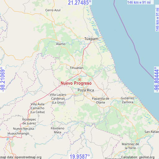
Nuevo Progreso GPS coordinates[2]
20° 37' 5.52" North, 97° 30' 27.216" West
| Map corner | latitude | longitude |
|---|---|---|
| Upper-left | 21.27485°, | -98.21069° |
| Center: | 20.6182°, | -97.50756° |
| Lower-right: | 19.9587°, | -96.80444° |
| Map W x H: | 146.3×146.3 km | = 90.9×90.9mi |
| max Lat: | 32.7° ⇑29.7% North |
| Nuevo Progreso: | 20.6182° |
| min Lat: | ⇓70.3% South 14.53588° |
| min Long | Nuevo Progreso | max Long |
| -117.105° | -97.50756° | -86.73105° |
| W 69.4%⇐ | ⇒30.6% E |
Elevation
Elevation of Nuevo Progreso is 92 m = 302 ft, and this is 1161.7 m = 3811 ft below average elevation for this country.
| Max E: |
3497 m = 11473 ft | 80.2% |
| Avg. | 1253.7 m = 4113 ft | |
| Nuevo Progreso | 92 m = 302 ft | |
Min E: |
-1 m = -3 ft | 19.8% |
See also: Mexico elevation on elevation.city.
Geographical zone
Nuevo Progreso is located in North Torrid zone (between Equator and Tropic of Cancer). Distance of this Northern Tropic circle is 313.4 km =194.7 mi to North.| Distance of | km | miles | from Nuevo Progreso |
|---|---|---|---|
| North Pole | 7714.5 | 4793.6 | to North |
| Arctic Circle | 5108.6 | 3174.3 | to North |
| Tropic Cancer | 313.4 | 194.7 | to North |
| Equator | 2292.5 | 1424.5 | to South |


Nearby cities:
15 places around Nuevo Progreso: (largest is in red/bold)
• El Copal
6.1 km =3.8 mi,  269°
269°
• El Palmar
8.2 km =5.1 mi,  99°
99°
• El Águila
5.5 km =3.4 mi,  75°
75°
• Emiliano Zapata
8 km =5 mi,  193°
193°
• Enrique Rodríguez Cano (Zapotalillo)
6.3 km =3.9 mi,  317°
317°
• Fraccionamiento la Florida
9 km =5.6 mi,  113°
113°
• Huizotate
4 km =2.5 mi,  212°
212°
• La Isla (Kilómetro 10)
1.3 km =0.8 mi,  150°
150°
• La Isla Km 10
1.5 km =0.9 mi, 146°
• Miguel Hidalgo
7.3 km =4.5 mi,  175°
175°
• Plan de Ayala
8.6 km =5.3 mi, 153°
• Rancho Nuevo
6 km =3.7 mi,  126°
126°
• Totolapa
7.4 km =4.6 mi, 154°
• Villa de las Flores
9 km =5.6 mi,  121°
121°
• Úrsulo Galván
7.4 km =4.6 mi, 103°
Sources, notices
• [Note1] Compared only with cities in Mexico existing in our database
• [Src1] Map data: © OpenStreetMap contributors (CC-BY-SA)
• [Src2] Other city data from geonames.org with taken over terms of usage.
• [Src3] Geographical zone / Annual Mean Temperature by Robert A. Rohde @ Wikipedia
