La Isla Km 10 geodata
La Isla Km 10 (Veracruz) is a populated place; located in Mexico in America/Mexico_City (GMT-6) time zone. With population of 3,500 people, there are 2611 cities with bigger population in this country. Compared to other cities in Mexico, 70.1% of cities are located further ↓South; 69.5% of cities are located further ←West and 81.5% of cities have higher elevation than La Isla Km 10. Note1


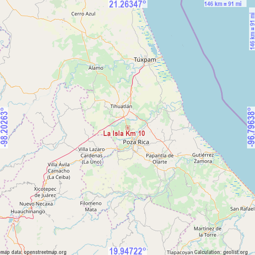
La Isla Km 10 GPS coordinates[2]
20° 36' 24.372" North, 97° 29' 58.2" West
| Map corner | latitude | longitude |
|---|---|---|
| Upper-left | 21.26347°, | -98.20263° |
| Center: | 20.60677°, | -97.4995° |
| Lower-right: | 19.94722°, | -96.79638° |
| Map W x H: | 146.4×146.4 km | = 91×91mi |
| max Lat: | 32.7° ⇑29.9% North |
| La Isla Km 10: | 20.60677° |
| min Lat: | ⇓70.1% South 14.53588° |
| min Long | La Isla Km 10 | max Long |
| -117.105° | -97.4995° | -86.73105° |
| W 69.5%⇐ | ⇒30.5% E |
Elevation
Elevation of La Isla Km 10 is 76 m = 249 ft, and this is 1177.7 m = 3864 ft below average elevation for this country.
| Max E: |
3497 m = 11473 ft | 81.5% |
| Avg. | 1253.7 m = 4113 ft | |
| La Isla Km 10 | 76 m = 249 ft | |
Min E: |
-1 m = -3 ft | 18.5% |
See also: Mexico elevation on elevation.city.
Geographical zone
La Isla Km 10 is located in North Torrid zone (between Equator and Tropic of Cancer). Distance of this Northern Tropic circle is 314.7 km =195.5 mi to North.| Distance of | km | miles | from La Isla Km 10 |
|---|---|---|---|
| North Pole | 7715.8 | 4794.4 | to North |
| Arctic Circle | 5109.9 | 3175.1 | to North |
| Tropic Cancer | 314.7 | 195.5 | to North |
| Equator | 2291.3 | 1423.7 | to South |


Nearby cities:
15 places around La Isla Km 10: (largest is in red/bold)
• El Copal
7 km =4.3 mi,  280°
280°
• El Palmar
7.2 km =4.5 mi,  90°
90°
• El Águila
5.2 km =3.2 mi,  59°
59°
• Emiliano Zapata
7 km =4.3 mi,  202°
202°
• Enrique Rodríguez Cano (Zapotalillo)
7.8 km =4.8 mi,  318°
318°
• Fraccionamiento la Florida
7.7 km =4.8 mi,  106°
106°
• Huizotate
3.7 km =2.3 mi,  234°
234°
• La Isla (Kilómetro 10)
0.2 km =0.1 mi,  306°
306°
• Miguel Hidalgo
6 km =3.7 mi,  182°
182°
• Nuevo Progreso
1.5 km =0.9 mi,  326°
326°
• Plan de Ayala
7.1 km =4.4 mi,  155°
155°
• Rancho Nuevo
4.6 km =2.9 mi,  120°
120°
• Totolapa
5.9 km =3.7 mi, 156°
• Villa de las Flores
7.6 km =4.7 mi, 116°
• Úrsulo Galván
6.3 km =3.9 mi, 93°
Sources, notices
• [Note1] Compared only with cities in Mexico existing in our database
• [Src1] Map data: © OpenStreetMap contributors (CC-BY-SA)
• [Src2] Other city data from geonames.org with taken over terms of usage.
• [Src3] Geographical zone / Annual Mean Temperature by Robert A. Rohde @ Wikipedia
