El Copal geodata
El Copal (Veracruz) is a populated place; located in Mexico in America/Mexico_City (GMT-6) time zone. With population of 988 people, there are 8815 cities with bigger population in this country. Compared to other cities in Mexico, 70.3% of cities are located further ↓South; 68.8% of cities are located further ←West and 82.2% of cities have higher elevation than El Copal. Note1


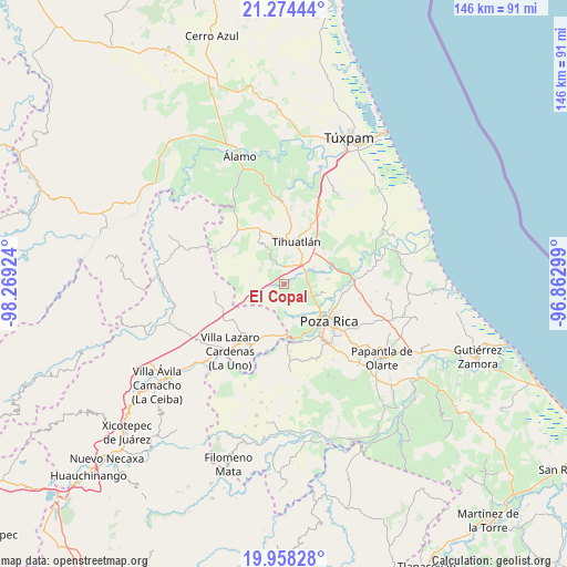
El Copal GPS coordinates[2]
20° 37' 4.008" North, 97° 33' 57.996" West
| Map corner | latitude | longitude |
|---|---|---|
| Upper-left | 21.27444°, | -98.26924° |
| Center: | 20.61778°, | -97.56611° |
| Lower-right: | 19.95828°, | -96.86299° |
| Map W x H: | 146.3×146.3 km | = 90.9×90.9mi |
| max Lat: | 32.7° ⇑29.7% North |
| El Copal: | 20.61778° |
| min Lat: | ⇓70.3% South 14.53588° |
| min Long | El Copal | max Long |
| -117.105° | -97.56611° | -86.73105° |
| W 68.8%⇐ | ⇒31.2% E |
Elevation
Elevation of El Copal is 68 m = 223 ft, and this is 1185.7 m = 3890 ft below average elevation for this country.
| Max E: |
3497 m = 11473 ft | 82.2% |
| Avg. | 1253.7 m = 4113 ft | |
| El Copal | 68 m = 223 ft | |
Min E: |
-1 m = -3 ft | 17.8% |
See also: Mexico elevation on elevation.city.
Geographical zone
El Copal is located in North Torrid zone (between Equator and Tropic of Cancer). Distance of this Northern Tropic circle is 313.4 km =194.7 mi to North.| Distance of | km | miles | from El Copal |
|---|---|---|---|
| North Pole | 7714.6 | 4793.6 | to North |
| Arctic Circle | 5108.7 | 3174.4 | to North |
| Tropic Cancer | 313.4 | 194.7 | to North |
| Equator | 2292.5 | 1424.5 | to South |


Nearby cities:
15 places around El Copal: (largest is in red/bold)
• Antonio M. Quirazco
7.1 km =4.4 mi,  210°
210°
• El Águila
11.5 km =7.1 mi,  82°
82°
• Emiliano Zapata
8.8 km =5.5 mi,  151°
151°
• Enrique Rodríguez Cano (Zapotalillo)
5 km =3.1 mi,  21°
21°
• Huizotate
5.2 km =3.2 mi,  130°
130°
• Jiliapa Segundo
8.5 km =5.3 mi,  335°
335°
• La Guadalupe
11.8 km =7.3 mi,  319°
319°
• La Isla (Kilómetro 10)
6.8 km =4.2 mi,  99°
99°
• La Isla Km 10
7 km =4.3 mi, 100°
• Miguel Hidalgo
9.8 km =6.1 mi,  137°
137°
• Nuevo Progreso
6.1 km =3.8 mi,  89°
89°
• Plan de Ayala
12.5 km =7.8 mi, 127°
• Rancho Nuevo
11.5 km =7.1 mi,  107°
107°
• Tihuatlan
11.3 km =7 mi, 17°
• Totolapa
11.5 km =7.1 mi, 125°
Sources, notices
• [Note1] Compared only with cities in Mexico existing in our database
• [Src1] Map data: © OpenStreetMap contributors (CC-BY-SA)
• [Src2] Other city data from geonames.org with taken over terms of usage.
• [Src3] Geographical zone / Annual Mean Temperature by Robert A. Rohde @ Wikipedia
