Atequexquitla geodata
Atequexquitla (Puebla) is a populated place; located in Mexico in America/Mexico_City (GMT-6) time zone. With population of 858 people, there are 10191 cities with bigger population in this country. Compared to other cities in Mexico, 62.8% of cities are located further ↓South; 65% of cities are located further ←West and 64.7% of cities have higher elevation than Atequexquitla. Note1


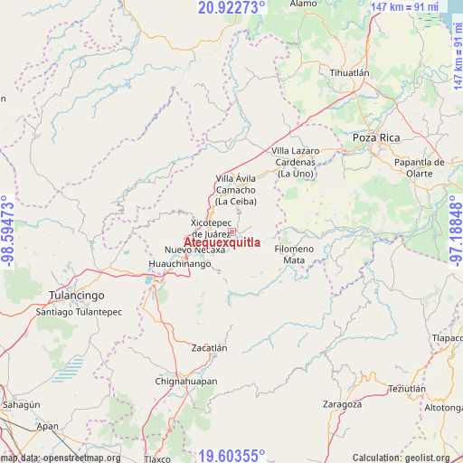
Atequexquitla GPS coordinates[2]
20° 15' 52.344" North, 97° 53' 29.76" West
| Map corner | latitude | longitude |
|---|---|---|
| Upper-left | 20.92273°, | -98.59473° |
| Center: | 20.26454°, | -97.8916° |
| Lower-right: | 19.60355°, | -97.18848° |
| Map W x H: | 146.7×146.7 km | = 91.2×91.2mi |
| max Lat: | 32.7° ⇑37.2% North |
| Atequexquitla: | 20.26454° |
| min Lat: | ⇓62.8% South 14.53588° |
| min Long | Atequexquitla | max Long |
| -117.105° | -97.8916° | -86.73105° |
| W 65%⇐ | ⇒35% E |
Elevation
Elevation of Atequexquitla is 707 m = 2320 ft, and this is 546.7 m = 1794 ft below average elevation for this country.
| Max E: |
3497 m = 11473 ft | 64.7% |
| Avg. | 1253.7 m = 4113 ft | |
| Atequexquitla | 707 m = 2320 ft | |
Min E: |
-1 m = -3 ft | 35.3% |
See also: Mexico elevation on elevation.city.
Geographical zone
Atequexquitla is located in North Torrid zone (between Equator and Tropic of Cancer). Distance of this Northern Tropic circle is 352.7 km =219.2 mi to North.| Distance of | km | miles | from Atequexquitla |
|---|---|---|---|
| North Pole | 7753.9 | 4818 | to North |
| Arctic Circle | 5148 | 3198.8 | to North |
| Tropic Cancer | 352.7 | 219.2 | to North |
| Equator | 2253.2 | 1400.1 | to South |


Nearby cities:
15 places around Atequexquitla: (largest is in red/bold)
• Ahuaxintitla
1.3 km =0.8 mi,  198°
198°
• Cinco de Octubre
4.9 km =3 mi,  115°
115°
• La Unión
2.1 km =1.3 mi,  98°
98°
• Lomas Verdes
6 km =3.7 mi,  267°
267°
• Los Pinos
6.2 km =3.9 mi,  224°
224°
• Mazacoatlán
5.4 km =3.4 mi, 215°
• Morelos
5.3 km =3.3 mi,  262°
262°
• Ocomantla
2.3 km =1.4 mi,  186°
186°
• Patla
4.4 km =2.7 mi,  114°
114°
• San Antonio Ocopetlatlán
6 km =3.7 mi,  251°
251°
• San Pedro Itztla
4.6 km =2.9 mi,  284°
284°
• Tecpatlán
3.8 km =2.4 mi,  137°
137°
• Telolotla
6.1 km =3.8 mi, 200°
• Tlaxcalantongo
5.9 km =3.7 mi,  20°
20°
• Zihuateutla
1.6 km =1 mi,  165°
165°
Sources, notices
• [Note1] Compared only with cities in Mexico existing in our database
• [Src1] Map data: © OpenStreetMap contributors (CC-BY-SA)
• [Src2] Other city data from geonames.org with taken over terms of usage.
• [Src3] Geographical zone / Annual Mean Temperature by Robert A. Rohde @ Wikipedia
