San Antonio Ocopetlatlán geodata
San Antonio Ocopetlatlán (Puebla) is a populated place; located in Mexico in America/Mexico_City (GMT-6) time zone. With population of 1,082 people, there are 8049 cities with bigger population in this country. Compared to other cities in Mexico, 62.4% of cities are located further ↓South; 64.3% of cities are located further ←West and 55% of cities have higher elevation than San Antonio Ocopetlatlán. Note1
Current local time in San Antonio Ocopetlatlán:
11:18 AM, MondayDifference from your time zone: hours


San Antonio Ocopetlatlán GPS coordinates[2]
20° 14' 49.308" North, 97° 56' 46.356" West
| Map corner | latitude | longitude |
|---|---|---|
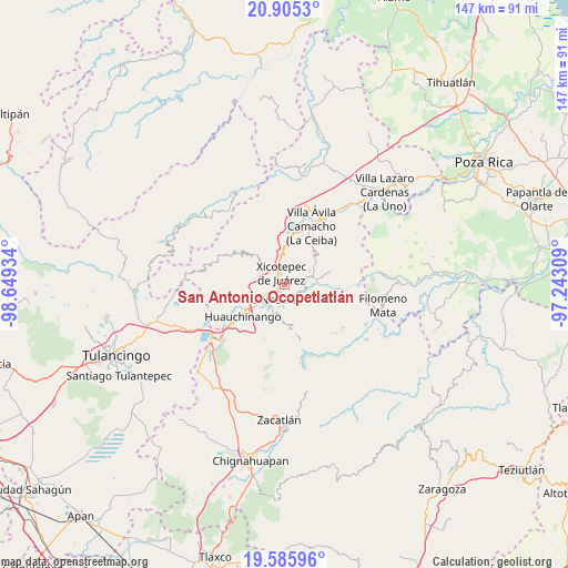
| Upper-left | 20.9053°, | -98.64934° |
| Center: | 20.24703°, | -97.94621° |
| Lower-right: | 19.58596°, | -97.24309° |
| Map W x H: | 146.7×146.7 km | = 91.2×91.2mi |
| max Lat: | 32.7° ⇑37.6% North |
| San Antonio Ocopetlatlán: | 20.24703° |
| min Lat: | ⇓62.4% South 14.53588° |
| min Long | San Antonio Oco | max Long |
| -117.105° | -97.94621° | -86.73105° |
| W 64.3%⇐ | ⇒35.7% E |
Elevation
Elevation of San Antonio Ocopetlatlán is 1197 m = 3927 ft, and this is 56.7 m = 186 ft below average elevation for this country.
| Max E: |
3497 m = 11473 ft | 55% |
| Avg. | 1253.7 m = 4113 ft | |
| San Antonio Ocopetlatlán | 1197 m = 3927 ft | |
Min E: |
-1 m = -3 ft | 45% |
See also: Mexico elevation on elevation.city.
Geographical zone
San Antonio Ocopetlatlán is located in North Torrid zone (between Equator and Tropic of Cancer). Distance of this Northern Tropic circle is 354.7 km =220.4 mi to North.| Distance of | km | miles | from San Antonio Ocopetlatlán |
|---|---|---|---|
| North Pole | 7755.8 | 4819.2 | to North |
| Arctic Circle | 5149.9 | 3200 | to North |
| Tropic Cancer | 354.7 | 220.4 | to North |
| Equator | 2251.3 | 1398.9 | to South |


Nearby cities:
15 places around San Antonio Ocopetlatlán: (largest is in red/bold)
• Ahuaxintitla
5.3 km =3.3 mi,  82°
82°
• Duraznotla
3.6 km =2.2 mi,  297°
297°
• Lagunillas
2.6 km =1.6 mi,  177°
177°
• Lomas Verdes
1.7 km =1.1 mi,  350°
350°
• Los Pinos
2.8 km =1.7 mi,  151°
151°
• Mazacoatlán
3.6 km =2.2 mi,  133°
133°
• Morelos
1.4 km =0.9 mi,  18°
18°
• Necaxaltépetl
5.4 km =3.4 mi,  255°
255°
• Ocomantla
5.4 km =3.4 mi,  93°
93°
• San Isidro
1.6 km =1 mi,  282°
282°
• San Pedro Itztla
3.3 km =2.1 mi, 21°
• Telolotla
5.2 km =3.2 mi,  136°
136°
• Tierra Negra
1.2 km =0.7 mi,  249°
249°
• Tzitzicazapa
4.9 km =3 mi,  169°
169°
• Xicotepec de Juárez
3.6 km =2.2 mi,  334°
334°
Sources, notices
• [Note1] Compared only with cities in Mexico existing in our database
• [Src1] Map data: © OpenStreetMap contributors (CC-BY-SA)
• [Src2] Other city data from geonames.org with taken over terms of usage.
• [Src3] Geographical zone / Annual Mean Temperature by Robert A. Rohde @ Wikipedia
