Tecpatlán geodata
Tecpatlán (Puebla) is a populated place; located in Mexico in America/Mexico_City (GMT-6) time zone. With population of 591 people, there are 14530 cities with bigger population in this country. Compared to other cities in Mexico, 62.2% of cities are located further ↓South; 65.2% of cities are located further ←West and 67.9% of cities have higher elevation than Tecpatlán. Note1


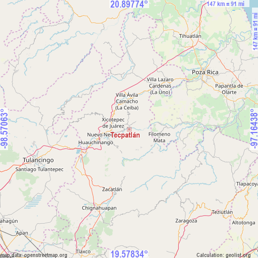
Tecpatlán GPS coordinates[2]
20° 14' 21.984" North, 97° 52' 3" West
| Map corner | latitude | longitude |
|---|---|---|
| Upper-left | 20.89774°, | -98.57063° |
| Center: | 20.23944°, | -97.8675° |
| Lower-right: | 19.57834°, | -97.16438° |
| Map W x H: | 146.7×146.7 km | = 91.2×91.2mi |
| max Lat: | 32.7° ⇑37.8% North |
| Tecpatlán: | 20.23944° |
| min Lat: | ⇓62.2% South 14.53588° |
| min Long | Tecpatlán | max Long |
| -117.105° | -97.8675° | -86.73105° |
| W 65.2%⇐ | ⇒34.8% E |
Elevation
Elevation of Tecpatlán is 536 m = 1759 ft, and this is 717.7 m = 2355 ft below average elevation for this country.
| Max E: |
3497 m = 11473 ft | 67.9% |
| Avg. | 1253.7 m = 4113 ft | |
| Tecpatlán | 536 m = 1759 ft | |
Min E: |
-1 m = -3 ft | 32.1% |
See also: Mexico elevation on elevation.city.
Geographical zone
Tecpatlán is located in North Torrid zone (between Equator and Tropic of Cancer). Distance of this Northern Tropic circle is 355.5 km =220.9 mi to North.| Distance of | km | miles | from Tecpatlán |
|---|---|---|---|
| North Pole | 7756.6 | 4819.7 | to North |
| Arctic Circle | 5150.8 | 3200.6 | to North |
| Tropic Cancer | 355.5 | 220.9 | to North |
| Equator | 2250.4 | 1398.3 | to South |


Nearby cities:
15 places around Tecpatlán: (largest is in red/bold)
• Ahuacatlaya
8 km =5 mi,  148°
148°
• Ahuaxintitla
3.3 km =2.1 mi,  297°
297°
• Atequexquitla
3.8 km =2.4 mi,  317°
317°
• Chicontla
3.9 km =2.4 mi,  82°
82°
• Cinco de Octubre
2 km =1.2 mi,  70°
70°
• El Encinal
2.8 km =1.7 mi,  134°
134°
• La Unión
2.5 km =1.6 mi,  350°
350°
• Los Pinos
7.1 km =4.4 mi,  256°
256°
• Mazacoatlán
5.8 km =3.6 mi,  253°
253°
• Ocomantla
2.8 km =1.7 mi,  281°
281°
• Patla
1.8 km =1.1 mi,  57°
57°
• San Pedro Tlaolantongo
6.9 km =4.3 mi,  97°
97°
• Telolotla
5.5 km =3.4 mi,  237°
237°
• Xochinanacatlán
5.9 km =3.7 mi,  212°
212°
• Zihuateutla
2.5 km =1.6 mi, 300°
Sources, notices
• [Note1] Compared only with cities in Mexico existing in our database
• [Src1] Map data: © OpenStreetMap contributors (CC-BY-SA)
• [Src2] Other city data from geonames.org with taken over terms of usage.
• [Src3] Geographical zone / Annual Mean Temperature by Robert A. Rohde @ Wikipedia
