Tlaxcalantongo geodata
Tlaxcalantongo (Puebla) is a populated place; located in Mexico in America/Mexico_City (GMT-6) time zone. With population of 1,948 people, there are 4471 cities with bigger population in this country. Compared to other cities in Mexico, 63.8% of cities are located further ↓South; 65.2% of cities are located further ←West and 65.5% of cities have higher elevation than Tlaxcalantongo. Note1


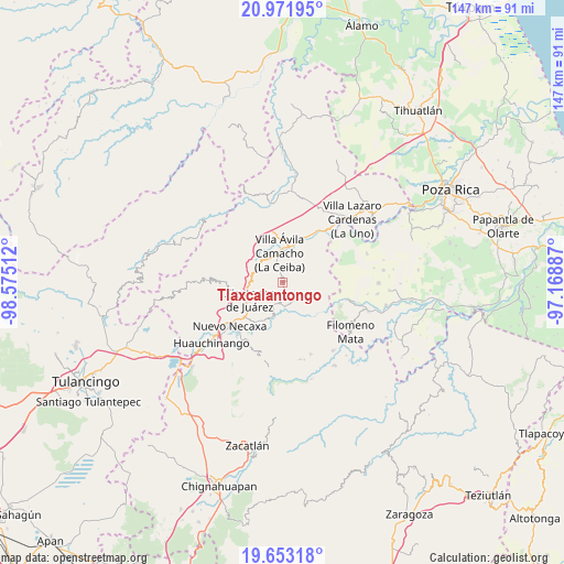
Tlaxcalantongo GPS coordinates[2]
20° 18' 50.292" North, 97° 52' 19.164" West
| Map corner | latitude | longitude |
|---|---|---|
| Upper-left | 20.97195°, | -98.57512° |
| Center: | 20.31397°, | -97.87199° |
| Lower-right: | 19.65318°, | -97.16887° |
| Map W x H: | 146.6×146.6 km | = 91.1×91.1mi |
| max Lat: | 32.7° ⇑36.2% North |
| Tlaxcalantongo: | 20.31397° |
| min Lat: | ⇓63.8% South 14.53588° |
| min Long | Tlaxcalantongo | max Long |
| -117.105° | -97.87199° | -86.73105° |
| W 65.2%⇐ | ⇒34.8% E |
Elevation
Elevation of Tlaxcalantongo is 661 m = 2169 ft, and this is 592.7 m = 1945 ft below average elevation for this country.
| Max E: |
3497 m = 11473 ft | 65.5% |
| Avg. | 1253.7 m = 4113 ft | |
| Tlaxcalantongo | 661 m = 2169 ft | |
Min E: |
-1 m = -3 ft | 34.5% |
See also: Mexico elevation on elevation.city.
Geographical zone
Tlaxcalantongo is located in North Torrid zone (between Equator and Tropic of Cancer). Distance of this Northern Tropic circle is 347.2 km =215.7 mi to North.| Distance of | km | miles | from Tlaxcalantongo |
|---|---|---|---|
| North Pole | 7748.4 | 4814.6 | to North |
| Arctic Circle | 5142.5 | 3195.4 | to North |
| Tropic Cancer | 347.2 | 215.7 | to North |
| Equator | 2258.7 | 1403.5 | to South |


Nearby cities:
15 places around Tlaxcalantongo: (largest is in red/bold)
• Ahuaxintitla
7.2 km =4.5 mi,  200°
200°
• Atequexquitla
5.9 km =3.7 mi, 200°
• Chicontla
8.9 km =5.5 mi,  150°
150°
• Cinco de Octubre
8 km =5 mi,  162°
162°
• Gilberto Camacho
6.8 km =4.2 mi,  348°
348°
• Jalapilla
7.6 km =4.7 mi,  322°
322°
• La Unión
5.8 km =3.6 mi,  179°
179°
• Ocomantla
8.1 km =5 mi, 196°
• Patla
7.6 km =4.7 mi, 164°
• San Lorenzo
7.8 km =4.8 mi,  301°
301°
• San Pedro Itztla
7.8 km =4.8 mi,  236°
236°
• Santa Rita
8 km =5 mi,  45°
45°
• Tecpatlán
8.3 km =5.2 mi, 176°
• Villa Avila Camacho
8 km =5 mi, 354°
• Zihuateutla
7.2 km =4.5 mi,  193°
193°
Sources, notices
• [Note1] Compared only with cities in Mexico existing in our database
• [Src1] Map data: © OpenStreetMap contributors (CC-BY-SA)
• [Src2] Other city data from geonames.org with taken over terms of usage.
• [Src3] Geographical zone / Annual Mean Temperature by Robert A. Rohde @ Wikipedia
