San Bartolo del Escobal geodata
San Bartolo del Escobal (Puebla) is a populated place; located in Mexico in America/Mexico_City (GMT-6) time zone. With population of 658 people, there are 13187 cities with bigger population in this country. Compared to other cities in Mexico, 66.3% of cities are located further ↓South; 67.7% of cities are located further ←West and 72.2% of cities have higher elevation than San Bartolo del Escobal. Note1
Current local time in San Bartolo del Escobal:
06:47 AM, WednesdayDifference from your time zone: hours


San Bartolo del Escobal GPS coordinates[2]
20° 25' 51.996" North, 97° 39' 46.008" West
| Map corner | latitude | longitude |
|---|---|---|
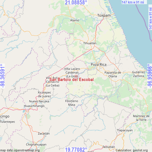
| Upper-left | 21.08858°, | -98.36591° |
| Center: | 20.43111°, | -97.66278° |
| Lower-right: | 19.77082°, | -96.95966° |
| Map W x H: | 146.5×146.5 km | = 91×91mi |
| max Lat: | 32.7° ⇑33.7% North |
| San Bartolo del Escobal: | 20.43111° |
| min Lat: | ⇓66.3% South 14.53588° |
| min Long | San Bartolo del | max Long |
| -117.105° | -97.66278° | -86.73105° |
| W 67.7%⇐ | ⇒32.3% E |
Elevation
Elevation of San Bartolo del Escobal is 321 m = 1053 ft, and this is 932.7 m = 3060 ft below average elevation for this country.
| Max E: |
3497 m = 11473 ft | 72.2% |
| Avg. | 1253.7 m = 4113 ft | |
| San Bartolo del Escobal | 321 m = 1053 ft | |
Min E: |
-1 m = -3 ft | 27.8% |
See also: Mexico elevation on elevation.city.
Geographical zone
San Bartolo del Escobal is located in North Torrid zone (between Equator and Tropic of Cancer). Distance of this Northern Tropic circle is 334.2 km =207.7 mi to North.| Distance of | km | miles | from San Bartolo del Escobal |
|---|---|---|---|
| North Pole | 7735.3 | 4806.5 | to North |
| Arctic Circle | 5129.4 | 3187.3 | to North |
| Tropic Cancer | 334.2 | 207.7 | to North |
| Equator | 2271.7 | 1411.6 | to South |


Nearby cities:
15 places around San Bartolo del Escobal: (largest is in red/bold)
• Calichar Palma Sola
11.7 km =7.3 mi,  84°
84°
• Chicualoque
5.4 km =3.4 mi,  178°
178°
• Coronel Tito Hernández
8.1 km =5 mi,  290°
290°
• Estrella Roja
2.1 km =1.3 mi,  297°
297°
• La Colonia Guadalupe
10.6 km =6.6 mi,  156°
156°
• La Libertad
3.8 km =2.4 mi,  307°
307°
• La Palma
9.6 km =6 mi,  256°
256°
• Nuevo Zoquiapan
10.3 km =6.4 mi,  274°
274°
• Paso de Coyutla
4 km =2.5 mi,  279°
279°
• Piedras Negras
10.4 km =6.5 mi, 276°
• San Fernando Coapechapa
8.3 km =5.2 mi,  148°
148°
• San Marcos
11.7 km =7.3 mi,  143°
143°
• Venustiano Carranza
8.4 km =5.2 mi,  356°
356°
• Villa Lázaro Cárdenas
5.2 km =3.2 mi, 311°
• Vizcaíno
11.5 km =7.1 mi,  59°
59°
Sources, notices
• [Note1] Compared only with cities in Mexico existing in our database
• [Src1] Map data: © OpenStreetMap contributors (CC-BY-SA)
• [Src2] Other city data from geonames.org with taken over terms of usage.
• [Src3] Geographical zone / Annual Mean Temperature by Robert A. Rohde @ Wikipedia
