La Libertad geodata
La Libertad (Puebla) is a populated place; located in Mexico in America/Mexico_City (GMT-6) time zone. With population of 689 people, there are 12616 cities with bigger population in this country. Compared to other cities in Mexico, 66.7% of cities are located further ↓South; 67.4% of cities are located further ←West and 71.9% of cities have higher elevation than La Libertad. Note1


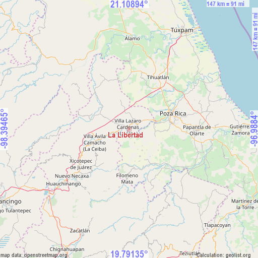
La Libertad GPS coordinates[2]
20° 27' 5.616" North, 97° 41' 29.472" West
| Map corner | latitude | longitude |
|---|---|---|
| Upper-left | 21.10894°, | -98.39465° |
| Center: | 20.45156°, | -97.69152° |
| Lower-right: | 19.79135°, | -96.9884° |
| Map W x H: | 146.5×146.5 km | = 91×91mi |
| max Lat: | 32.7° ⇑33.3% North |
| La Libertad: | 20.45156° |
| min Lat: | ⇓66.7% South 14.53588° |
| min Long | La Libertad | max Long |
| -117.105° | -97.69152° | -86.73105° |
| W 67.4%⇐ | ⇒32.6% E |
Elevation
Elevation of La Libertad is 332 m = 1089 ft, and this is 921.7 m = 3024 ft below average elevation for this country.
| Max E: |
3497 m = 11473 ft | 71.9% |
| Avg. | 1253.7 m = 4113 ft | |
| La Libertad | 332 m = 1089 ft | |
Min E: |
-1 m = -3 ft | 28.1% |
See also: Mexico elevation on elevation.city.
Geographical zone
La Libertad is located in North Torrid zone (between Equator and Tropic of Cancer). Distance of this Northern Tropic circle is 331.9 km =206.2 mi to North.| Distance of | km | miles | from La Libertad |
|---|---|---|---|
| North Pole | 7733.1 | 4805.1 | to North |
| Arctic Circle | 5127.2 | 3185.9 | to North |
| Tropic Cancer | 331.9 | 206.2 | to North |
| Equator | 2274 | 1413 | to South |


Nearby cities:
15 places around La Libertad: (largest is in red/bold)
• Chicualoque
8.3 km =5.2 mi,  157°
157°
• Coronel Tito Hernández
4.7 km =2.9 mi,  276°
276°
• El Tepetate
10.2 km =6.3 mi,  254°
254°
• Estrella Roja
1.8 km =1.1 mi,  138°
138°
• La Palma
7.8 km =4.8 mi,  234°
234°
• Nuevo Zoquiapan
7.4 km =4.6 mi,  258°
258°
• Paso de Coyutla
1.9 km =1.2 mi,  211°
211°
• Piedras Negras
7.4 km =4.6 mi, 261°
• San Bartolo del Escobal
3.8 km =2.4 mi,  127°
127°
• San Fernando Coapechapa
11.9 km =7.4 mi, 141°
• San José
12.5 km =7.8 mi,  355°
355°
• Santa María
13.9 km =8.6 mi,  78°
78°
• Venustiano Carranza
6.6 km =4.1 mi,  21°
21°
• Villa Lázaro Cárdenas
1.5 km =0.9 mi,  321°
321°
• Vizcaíno
13.4 km =8.3 mi,  74°
74°
Sources, notices
• [Note1] Compared only with cities in Mexico existing in our database
• [Src1] Map data: © OpenStreetMap contributors (CC-BY-SA)
• [Src2] Other city data from geonames.org with taken over terms of usage.
• [Src3] Geographical zone / Annual Mean Temperature by Robert A. Rohde @ Wikipedia
