La Palma geodata
La Palma (Veracruz) is a populated place; located in Mexico in America/Mexico_City (GMT-6) time zone. With population of 551 people, there are 15478 cities with bigger population in this country. Compared to other cities in Mexico, 65.9% of cities are located further ↓South; 66.7% of cities are located further ←West and 76.2% of cities have higher elevation than La Palma. Note1


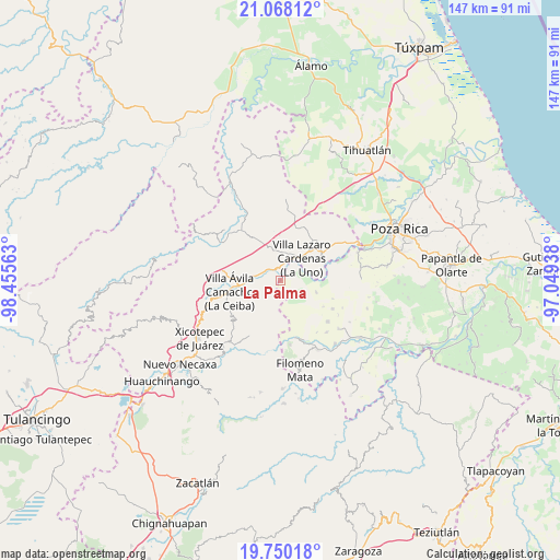
La Palma GPS coordinates[2]
20° 24' 38.016" North, 97° 45' 9" West
| Map corner | latitude | longitude |
|---|---|---|
| Upper-left | 21.06812°, | -98.45563° |
| Center: | 20.41056°, | -97.7525° |
| Lower-right: | 19.75018°, | -97.04938° |
| Map W x H: | 146.5×146.5 km | = 91×91mi |
| max Lat: | 32.7° ⇑34.1% North |
| La Palma: | 20.41056° |
| min Lat: | ⇓65.9% South 14.53588° |
| min Long | La Palma | max Long |
| -117.105° | -97.7525° | -86.73105° |
| W 66.7%⇐ | ⇒33.3% E |
Elevation
Elevation of La Palma is 178 m = 584 ft, and this is 1075.7 m = 3529 ft below average elevation for this country.
| Max E: |
3497 m = 11473 ft | 76.2% |
| Avg. | 1253.7 m = 4113 ft | |
| La Palma | 178 m = 584 ft | |
Min E: |
-1 m = -3 ft | 23.8% |
See also: Mexico elevation on elevation.city.
Geographical zone
La Palma is located in North Torrid zone (between Equator and Tropic of Cancer). Distance of this Northern Tropic circle is 336.5 km =209.1 mi to North.| Distance of | km | miles | from La Palma |
|---|---|---|---|
| North Pole | 7737.6 | 4807.9 | to North |
| Arctic Circle | 5131.7 | 3188.7 | to North |
| Tropic Cancer | 336.5 | 209.1 | to North |
| Equator | 2269.4 | 1410.1 | to South |


Nearby cities:
15 places around La Palma: (largest is in red/bold)
• Agua Linda
12.6 km =7.8 mi,  288°
288°
• Apapantilla
9.8 km =6.1 mi,  265°
265°
• Cerro Verde
7.8 km =4.8 mi,  179°
179°
• Chicualoque
10 km =6.2 mi,  108°
108°
• Coronel Tito Hernández
5.4 km =3.4 mi,  18°
18°
• El Tepetate
4 km =2.5 mi,  298°
298°
• Estrella Roja
8.2 km =5.1 mi,  66°
66°
• La Libertad
7.8 km =4.8 mi,  54°
54°
• Nuevo Zoquiapan
3.2 km =2 mi,  342°
342°
• Paso de Coyutla
6.1 km =3.8 mi,  61°
61°
• Piedras Negras
3.5 km =2.2 mi, 344°
• San Bartolo del Escobal
9.6 km =6 mi,  76°
76°
• Santa Rita
8.5 km =5.3 mi,  232°
232°
• Tenangulto
10 km =6.2 mi,  198°
198°
• Villa Lázaro Cárdenas
7.9 km =4.9 mi,  43°
43°
Sources, notices
• [Note1] Compared only with cities in Mexico existing in our database
• [Src1] Map data: © OpenStreetMap contributors (CC-BY-SA)
• [Src2] Other city data from geonames.org with taken over terms of usage.
• [Src3] Geographical zone / Annual Mean Temperature by Robert A. Rohde @ Wikipedia
