Potrero Horcón geodata
Potrero Horcón (Veracruz) is a populated place; located in Mexico in America/Mexico_City (GMT-6) time zone. With population of 735 people, there are 11887 cities with bigger population in this country. Compared to other cities in Mexico, 81.9% of cities are located further ↓South; 60% of cities are located further ←West and 77.4% of cities have higher elevation than Potrero Horcón. Note1


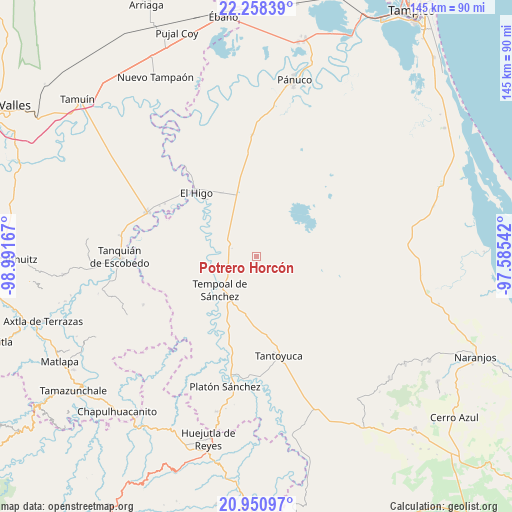
Potrero Horcón GPS coordinates[2]
21° 36' 22.176" North, 98° 17' 18.744" West
| Map corner | latitude | longitude |
|---|---|---|
| Upper-left | 22.25839°, | -98.99167° |
| Center: | 21.60616°, | -98.28854° |
| Lower-right: | 20.95097°, | -97.58542° |
| Map W x H: | 145.4×145.4 km | = 90.3×90.3mi |
| max Lat: | 32.7° ⇑18.1% North |
| Potrero Horcón: | 21.60616° |
| min Lat: | ⇓81.9% South 14.53588° |
| min Long | Potrero Horcón | max Long |
| -117.105° | -98.28854° | -86.73105° |
| W 60%⇐ | ⇒40% E |
Elevation
Elevation of Potrero Horcón is 143 m = 469 ft, and this is 1110.7 m = 3644 ft below average elevation for this country.
| Max E: |
3497 m = 11473 ft | 77.4% |
| Avg. | 1253.7 m = 4113 ft | |
| Potrero Horcón | 143 m = 469 ft | |
Min E: |
-1 m = -3 ft | 22.6% |
See also: Mexico elevation on elevation.city.
Geographical zone
Potrero Horcón is located in North Torrid zone (between Equator and Tropic of Cancer). Distance of this Northern Tropic circle is 203.5 km =126.4 mi to North.| Distance of | km | miles | from Potrero Horcón |
|---|---|---|---|
| North Pole | 7604.7 | 4725.3 | to North |
| Arctic Circle | 4998.8 | 3106.1 | to North |
| Tropic Cancer | 203.5 | 126.4 | to North |
| Equator | 2402.4 | 1492.8 | to South |


Nearby cities:
15 places around Potrero Horcón: (largest is in red/bold)
• Bellavista
21.3 km =13.2 mi,  297°
297°
• Cruz de Palma
9.1 km =5.7 mi,  176°
176°
• Cuchilla Chica
20.2 km =12.6 mi, 182°
• Cuve de Badeas
18.6 km =11.6 mi,  318°
318°
• Ejido Rancho Alegre
14.1 km =8.8 mi,  332°
332°
• El Rincón
18.5 km =11.5 mi, 184°
• La Estanzuela
21.7 km =13.5 mi, 179°
• La Peña
20.6 km =12.8 mi,  185°
185°
• Las Badeas
19.8 km =12.3 mi, 319°
• Nuevo Chicayán
21.3 km =13.2 mi,  34°
34°
• Palma Alta
20.1 km =12.5 mi,  161°
161°
• Placetas
17.7 km =11 mi,  166°
166°
• Rancho Nuevo
21 km =13 mi, 176°
• Tempoal de Sánchez
14.1 km =8.8 mi,  227°
227°
• Terrero
16.6 km =10.3 mi, 176°
Sources, notices
• [Note1] Compared only with cities in Mexico existing in our database
• [Src1] Map data: © OpenStreetMap contributors (CC-BY-SA)
• [Src2] Other city data from geonames.org with taken over terms of usage.
• [Src3] Geographical zone / Annual Mean Temperature by Robert A. Rohde @ Wikipedia
